IMAGES TAKEN NEAR TO
Wembley Gardens, NOTTINGHAM, NG9 3FE
Introduction
This page details the photographs taken nearby to Wembley Gardens, NG9 3FE by members of the Geograph project.
The Geograph project started in 2005 with the aim of publishing, organising and preserving representative images for every square kilometre of Great Britain, Ireland and the Isle of Man.

There are currently over 7.5m images from over14,400 individuals and you can help contribute to the project by visiting https://www.geograph.org.uk
Image Map
Images are licensed for reuse under creativecommons.org/licenses/by-sa/2.0
Notes
- Clicking on the map will re-center to the selected point.
- The higher the marker number, the further away the image location is from the centre of the postcode.
Image Listing (11 Images Found)
Images are licensed for reuse under creativecommons.org/licenses/by-sa/2.0
Image
Details
Distance
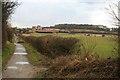
1
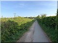
Track in Bramcote
Alongside the playing fields
Image: © Andrew Abbott
Taken: 24 Apr 2020
0.13 miles
2
Moor Lane, Bramcote
Looking north towards Moor Farm.
Image: © Andrew Abbott
Taken: 24 Apr 2020
0.15 miles
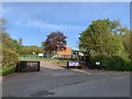
3
Moor Farm , Bramcote Hills
This is no longer a working farm due to the encroachment of housing development over recent decades.
Image: © Alan Murray-Rust
Taken: 25 Nov 2007
0.15 miles
4
Moor Lane, Bramcote
Looking south towards Bramcote
Image: © Andrew Abbott
Taken: 24 Apr 2020
0.16 miles
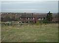
5
Moor Farm, Bramcote
From about 1971 this was a public house called the "Moor Farm Inn" until its closure a few years ago. The Bramcote Hills school buildings are in the trees on the hill to the right and a corner of the school playing field is in the foreground.
Image: © Tom Courtney
Taken: 9 Sep 2005
0.16 miles
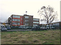
6
Brethren's Meeting Room
This place of worship is like a modern fortress - 2 m-high fence, keypad operation of electronic gates, CCTV everywhere, etc - a sign of the times? When I cycled past here on a previous Sunday this building was surrounded by at least 50 or 60 cars, but this morning it was empty. I think this must be the same site as Moor Farm [http://www.geograph.org.uk/photo/622485], which is now gone - it is still marked as a public house on the OS maps. Note the small cross on the fence on the right.
Image: © Oxymoron
Taken: 10 Aug 2008
0.18 miles
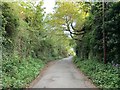
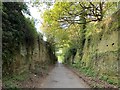
7
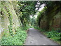
Moor Lane
This short section of the lane (now a bridleway along its entire length) is cut through the local sandstone ridge - for the rest of its length the lane is nowhere near as spectacular.
Image: © Oxymoron
Taken: 10 Aug 2008
0.19 miles
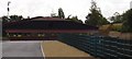
8
Bramcote Hills schools
A large secondary school complex serving principally Wollaton and Stapleford.
Image: © Alan Murray-Rust
Taken: 25 Nov 2007
0.20 miles
9
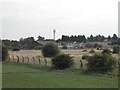
View toward Bramcote Hill over playing fields
With Bramcote Hills School next to the hill and a new pavilion not yet on the map.
Image: © David Lally
Taken: 16 Feb 2010
0.21 miles
10
Bramcote Hills College
From Moor Lane.
Image: © Andrew Abbott
Taken: 24 Apr 2020
0.25 miles