IMAGES TAKEN NEAR TO
County Close, NOTTINGHAM, NG9 1GD
Introduction
This page details the photographs taken nearby to County Close, NG9 1GD by members of the Geograph project.
The Geograph project started in 2005 with the aim of publishing, organising and preserving representative images for every square kilometre of Great Britain, Ireland and the Isle of Man.

There are currently over 7.5m images from over14,400 individuals and you can help contribute to the project by visiting https://www.geograph.org.uk
Image Map
Images are licensed for reuse under creativecommons.org/licenses/by-sa/2.0
Notes
- Clicking on the map will re-center to the selected point.
- The higher the marker number, the further away the image location is from the centre of the postcode.
Image Listing (446 Images Found)
Images are licensed for reuse under creativecommons.org/licenses/by-sa/2.0
Image
Details
Distance
1
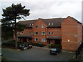
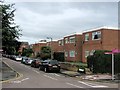
Housing Trust flats, Beeston
Housing Trust flats in Beeston near the railway station.
Image: © Andrew Abbott
Taken: 22 Mar 2010
0.01 miles
2
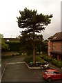
Pine tree near Beeston railway station
Image: © Andrew Abbott
Taken: 10 Jun 2010
0.01 miles
3

Mural under Meadow Lane
For Beeston station, presumably done by the children from the nursery here Image
Image: © David Lally
Taken: 3 Aug 2012
0.02 miles
4
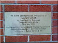
County Close, Beeston
Plaque for the opening of the Longhurst Housing development of County Close, Beeston, by Councillor John White, Mayor of Broxtowe on 29 May 1996.
Image: © Andrew Abbott
Taken: 24 Mar 2010
0.03 miles
6
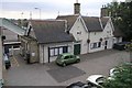
Beeston Station
The shield on one gable states 1847 the other M R - presumably Midland Railway
Image: © David Lally
Taken: 24 Oct 2007
0.03 miles
7
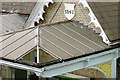
Beeston Station awnings
I thought the missing glass was a sign of neglect but all the awnings have the same two panes missing ??
Image: © David Lally
Taken: 24 Oct 2007
0.03 miles
9
Meadow Road, Beeston
The old road (left) led to a level crossing and was replaced in the 1960s with a bridge (right). There is signage here for cycle routes to the University, City Centre and river Trent.
Image: © Stephen Craven
Taken: 19 Jan 2020
0.03 miles
10
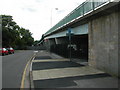
Meadow Road bridge and Beeston station
Meadow Road bridge taken from Station Road, with Beeston station sign. Three forms of transport all in one place, the underpass at the end of the wall on the right is Sustrans national route 6.
Image: © Peter Shone
Taken: 17 Sep 2005
0.03 miles