IMAGES TAKEN NEAR TO
NOTTINGHAM, NG90 4HQ
Introduction
This page details the photographs taken nearby to NG90 4HQ by members of the Geograph project.
The Geograph project started in 2005 with the aim of publishing, organising and preserving representative images for every square kilometre of Great Britain, Ireland and the Isle of Man.

There are currently over 7.5m images from over14,400 individuals and you can help contribute to the project by visiting https://www.geograph.org.uk
Image Map
Images are licensed for reuse under creativecommons.org/licenses/by-sa/2.0
Notes
- Clicking on the map will re-center to the selected point.
- The higher the marker number, the further away the image location is from the centre of the postcode.
Image Listing (41 Images Found)
Images are licensed for reuse under creativecommons.org/licenses/by-sa/2.0
Image
Details
Distance
1

Building D90 West
Wonderful Grade II* listed office building from 1966-8
List Entry Number:1268303 https://historicengland.org.uk/listing/the-list/list-entry/1268303
Image: © David Lally
Taken: 15 Jul 2021
0.09 miles
2

Building D90 West
Wonderful Grade II* listed office building from 1966-8
List Entry Number:1268303 https://historicengland.org.uk/listing/the-list/list-entry/1268303
Image: © David Lally
Taken: 15 Jul 2021
0.10 miles
3

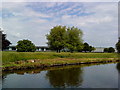
Boots - building D90 with reflected trees
The trees are reflected in the Beeston Canal.
D90 is Grade II* listed. List entry Number: 1268303
https://www.historicengland.org.uk/listing/the-list/list-entry/1268303
Image: © David Lally
Taken: 24 Feb 2016
0.12 miles
4

Boots - building D90
Grade II* listed List entry Number: 1268303
http://list.english-heritage.org.uk/resultsingle.aspx?uid=1268303
Image: © David Lally
Taken: 26 Mar 2014
0.12 miles
5

Boots - building D90
Grade II* listed List entry Number: 1268303
http://list.english-heritage.org.uk/resultsingle.aspx?uid=1268303
Image: © David Lally
Taken: 14 Mar 2014
0.12 miles
7

Undeveloped land off of Thane Road
View of the wasteland / undeveloped area from Thane Road looking towards Beeston Canal (which is located behind the trees in the distance). The site regularly floods in the autumn and winter periods. This picture was taken during the wet Autumn of 2023 during a particularly beautiful morning sunrise.
Image: © Tom Newman
Taken: 23 Oct 2023
0.13 miles

9
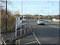
Thane Road Bridge
At this point Thane Road crosses the Beeston Canal and enters the Boots, Beeston, site.
Image: © Alan Murray-Rust
Taken: 27 Jan 2008
0.16 miles
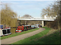
10
Thane Road Bridge
The land is built up on either side of the canal to keep buildings above the flood plain. The bridge is the eastern entrance into the Boots, Beeston, site.
There are official visitor moorings on the Canal here although it is a long way from any services as the area is entirely industrial.
Image: © Alan Murray-Rust
Taken: 27 Jan 2008
0.18 miles