IMAGES TAKEN NEAR TO
Main Street, NOTTINGHAM, NG8 6PE
Introduction
This page details the photographs taken nearby to Main Street, NG8 6PE by members of the Geograph project.
The Geograph project started in 2005 with the aim of publishing, organising and preserving representative images for every square kilometre of Great Britain, Ireland and the Isle of Man.

There are currently over 7.5m images from over14,400 individuals and you can help contribute to the project by visiting https://www.geograph.org.uk
Image Map
Images are licensed for reuse under creativecommons.org/licenses/by-sa/2.0
Notes
- Clicking on the map will re-center to the selected point.
- The higher the marker number, the further away the image location is from the centre of the postcode.
Image Listing (136 Images Found)
Images are licensed for reuse under creativecommons.org/licenses/by-sa/2.0
Image
Details
Distance
1
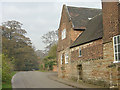
Strelley Hall stables
The buttresses are probably part of the old medieval hall.
Image: © Alan Murray-Rust
Taken: 4 Nov 2007
0.00 miles
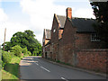
2
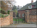
The gateway into the former stable yard at Strelley Hall
The roof of the hall can be seen in the distance with various outbuildings in between.
Image: © Alan Murray-Rust
Taken: 4 Nov 2007
0.01 miles
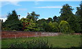
3
Strelley, Nottingham
These were once heated greenhouses on the Strelley Hall Estate. They were converted into a private residence at some time. This is a view from Main Street.
Image: © David Hallam-Jones
Taken: 14 Sep 2015
0.01 miles
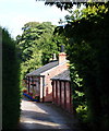
4
Strelley Hall Stables: another view
Looking in the opposite direction to Image The uneven paving on the pavement is due to the very old Monks Way stones; see Image The gateway to Image is on the right.
Image: © Kate Jewell
Taken: 14 Jan 2008
0.01 miles
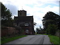
5
Strelley Hall stable block
The outbuildings and stable block of the present Hall, which dates from 1789-92, incorporate parts of the buttressed stone walls of the mediaeval manor house.
Image: © John Sutton
Taken: 19 May 2011
0.02 miles
6
Strelley, Nottingham
These Grade II-listed kitchen-garden walls lie 250 metres north west of Strelley Hall, forming part of Strelley Lodge on the Strelley Hall Estate. They are seen here from Main Street.
Image: © David Hallam-Jones
Taken: 14 Sep 2015
0.03 miles
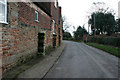
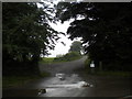
7
Main Street, Strelley
Looking down the hill, with the top of the church tower showing over the house on the left.
Image: © Oxymoron
Taken: 10 Aug 2008
0.03 miles
8
East end of Robbinetts Lane, Strelley
Seen from Main Street.
Image: © Richard Vince
Taken: 25 Sep 2013
0.04 miles
9
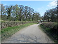
Approaching Strelley
Following the bridleway from Strelley Park Farm.
Image: © Chris Heaton
Taken: 30 Mar 2012
0.05 miles
10
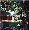
Strelley: derelict farm buildings, 1967
These buildings, New Yard on old maps, were derelict in the late 1960s and are no longer there. The corner of the lane to Cossall is now thickly wooded.
Image: © John Sutton
Taken: Unknown
0.05 miles