IMAGES TAKEN NEAR TO
Western Boulevard, NOTTINGHAM, NG8 5GL
Introduction
This page details the photographs taken nearby to Western Boulevard, NG8 5GL by members of the Geograph project.
The Geograph project started in 2005 with the aim of publishing, organising and preserving representative images for every square kilometre of Great Britain, Ireland and the Isle of Man.

There are currently over 7.5m images from over14,400 individuals and you can help contribute to the project by visiting https://www.geograph.org.uk
Image Map
Images are licensed for reuse under creativecommons.org/licenses/by-sa/2.0
Notes
- Clicking on the map will re-center to the selected point.
- The higher the marker number, the further away the image location is from the centre of the postcode.
Image Listing (32 Images Found)
Images are licensed for reuse under creativecommons.org/licenses/by-sa/2.0
Image
Details
Distance
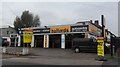
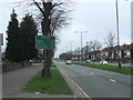
1
Looking south west on Western Boulevard (A6514)
Image: © JThomas
Taken: 27 Mar 2017
0.03 miles
3
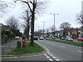
Western Boulevard (A6514)
Showing position of Postbox No. NG8 292.
See Image] for postbox.
Image: © JThomas
Taken: 27 Mar 2017
0.10 miles
4
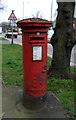
George VI postbox on Western Boulevard (A6514)
Postbox No. NG8 292.
See Image] for context.
Image: © JThomas
Taken: 27 Mar 2017
0.10 miles
5
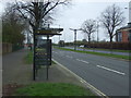
Bus stop and shelter on Western Boulevard (A6514)
Opposite Bluecoat School (Nottingham Bluecoat Academy).
Image: © JThomas
Taken: 27 Mar 2017
0.11 miles
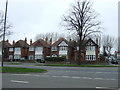
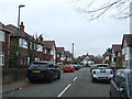
6
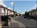
Newlyn Drive
This road of detached houses is very typical of the western suburbs developed in the 1930s. I must have walked or cycled along here many times in the 1950s (when most of the window and door woodwork was green-and-cream, or grained), on my way to play at Melbourne Park, which is behind the houses on the left.
Image: © John Sutton
Taken: 11 May 2010
0.11 miles
7
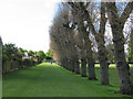
Melbourne Park: poplars which once bordered a railway
This view, from near the Newlyn Gardens entrance to the park, shows what in my childhood in the 1950s was the shunting neck of the National Coal Board railway line which connected Babbington (Cinderhill) Colliery with the sidings at the Nuthall Road landsale wharf (some way behind the camera). This railway had originally been built by Thomas North, the colliery owner, to connect Babbington to the Nottingham Canal, due south at Wollaton Road, and later the Midland Railway line from Radford to Trowell at Babbington Sidings, near where Western Boulevard bridge now stands. The line south of Melbourne Park had been long abandoned (since the building of Western Boulevard in the 1930s) by the time I watched a little green locomotive named Peter shunting NCB East Midlands Division No 6 Area wagons, which were black with white lettering and bright yellow corner ironwork.
Image: © John Sutton
Taken: 11 May 2010
0.11 miles
8
Nuthall Gardens, Nottingham
Off Western Boulevard (A6514).
Image: © JThomas
Taken: 27 Mar 2017
0.11 miles
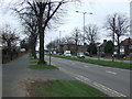
9
Western Boulevard (A6514)
Looking south west on the Nottingham Ring Road.
Image: © JThomas
Taken: 27 Mar 2017
0.12 miles