IMAGES TAKEN NEAR TO
Glaisdale Parkway, NOTTINGHAM, NG8 4JX
Introduction
This page details the photographs taken nearby to Glaisdale Parkway, NG8 4JX by members of the Geograph project.
The Geograph project started in 2005 with the aim of publishing, organising and preserving representative images for every square kilometre of Great Britain, Ireland and the Isle of Man.

There are currently over 7.5m images from over14,400 individuals and you can help contribute to the project by visiting https://www.geograph.org.uk
Image Map
Images are licensed for reuse under creativecommons.org/licenses/by-sa/2.0
Notes
- Clicking on the map will re-center to the selected point.
- The higher the marker number, the further away the image location is from the centre of the postcode.
Image Listing (11 Images Found)
Images are licensed for reuse under creativecommons.org/licenses/by-sa/2.0
Image
Details
Distance
1
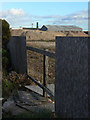
Demolition site on Glaisdale Drive
Changing economics has resulted in the decay of some of the older established industries in Bilborough.
Image: © Alan Murray-Rust
Taken: 25 Oct 2009
0.06 miles
2
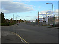
Glaisdale Drive
The southern part of the large Bilborough estate was zoned for industry, and Glaisdale Drive provides the boundary between residential and industry.
Image: © Alan Murray-Rust
Taken: 25 Oct 2009
0.16 miles
3
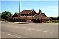
The Poacher's Tavern
On Glaisdale Road, Bilborough
Image: © David Lally
Taken: 9 Jun 2008
0.20 miles
4
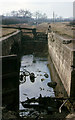
Nottingham Canal Wollaton Flight
About halfway down the flight of locks on the Nottingham Canal, looking towards the summit level, in 1963.The exact date of the shot is not known other than the year.
Image: © Richard Bird
Taken: 20 Apr 1963
0.21 miles
6
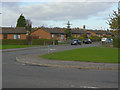
Bramerton Road
These modern bungalows, intended for elderly residents, replaced a large development of traditional post war pre-fabs.
Image: © Alan Murray-Rust
Taken: 25 Oct 2009
0.22 miles
7
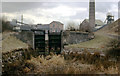
Nottingham Canal and Colliery 1963
Accessed by way of Woodyard Lane, the Nottingham Canal climbed by a succession of locks to reach its summit level close by Wollaton Colliery. At this time, in 1963, many of the lock gates had been vandalised and many were missing. Today, it is hard to comprehend that this scene existed, since now the area has been covered by modern housing.
Image: © Richard Bird
Taken: 21 Mar 1963
0.22 miles

9
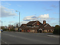
The Poachers Tavern
Now operating as an Indian curry restaurant.
Image: © Alan Murray-Rust
Taken: 25 Oct 2009
0.23 miles
10
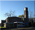
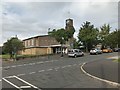
Parish Church of St John the Baptist, Bilborough
According to a passerby, this is exactly 50 years old.
Image: © Oxymoron
Taken: 3 Dec 2008
0.24 miles