IMAGES TAKEN NEAR TO
Oakfield Close, NOTTINGHAM, NG8 2SR
Introduction
This page details the photographs taken nearby to Oakfield Close, NG8 2SR by members of the Geograph project.
The Geograph project started in 2005 with the aim of publishing, organising and preserving representative images for every square kilometre of Great Britain, Ireland and the Isle of Man.

There are currently over 7.5m images from over14,400 individuals and you can help contribute to the project by visiting https://www.geograph.org.uk
Image Map
Images are licensed for reuse under creativecommons.org/licenses/by-sa/2.0
Notes
- Clicking on the map will re-center to the selected point.
- The higher the marker number, the further away the image location is from the centre of the postcode.
Image Listing (23 Images Found)
Images are licensed for reuse under creativecommons.org/licenses/by-sa/2.0
Image
Details
Distance
1
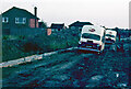
Humberstone Road, Wollaton
The quality of this old colour slide is far from ideal but the scene is of interest. At the time Humberstone Road was being built and, as was often the case in those days around building sites, no attempt was made to give the new roads a temporary surface, resulting in a quagmire after rain. On this summer evening in 1969 the driver of an ice cream van had, for some inexplicable reason, attempted to bring his vehicle this way. The inevitable happened and he got hopelessly stuck in the mud (and he couldn't even blame the SatNav!). He must somehow have contacted his company because they sent out another identical van to tow him out. Unfortunately the plan failed miserably when the second van got just as stuck as the first.
As an 11-year old witnessing this spectacular display of adult incompetence I, of course, found the whole thing hysterical and rushed home to get my camera. By the time I got back the light was fading but I got the shot (I imagine now that the two drivers were less than pleased to have an irritating kid around doubled up with laughter and taking a photograph). How the situation was eventually resolved is lost to history but I seem to recall they had gone by morning.
Image: © Stephen McKay
Taken: Unknown
0.12 miles
2
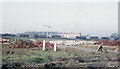
Housing development - Wollaton and Balloon Wood
This scene has changed beyond all recognition since this photograph was taken late in 1967. In the foreground development was under way extending the large area of private housing that appeared to the south of Wollaton Vale and north west of Bramcote Lane from the 1950s to the 1970s. Nowadays, of course, sites like this would be locked in securely behind yards of Heras fencing but no such precautions were deemed necessary then. Beyond that, and separated by a railway line, the flats at Balloon Wood were being built. The flats were intended to house people who had lost their homes as inner city slums were cleared but they were never successful, unpopular with residents and suffering from construction defects, and were demolished in 1984 to be replaced by an estate of conventional houses.
Image: © Stephen McKay
Taken: Unknown
0.14 miles
3
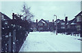
Redwood Avenue, Wollaton
Seen here on a snowy winter's day at the beginning of 1968, the houses here date from the mid-1950s, forming part of what was originally called the Model Farm Estate (on whose land they were built).
Image: © Stephen McKay
Taken: Unknown
0.16 miles
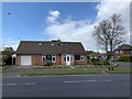
4
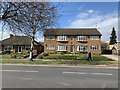
Grangewood House
Bramcote Lane, Wollaton.
Image: © Andrew Abbott
Taken: 29 Mar 2020
0.18 miles
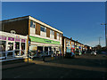
5
Wollaton shops
Bramcote Lane, Wollaton
Image: © Andrew Abbott
Taken: 29 Mar 2020
0.18 miles
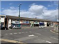
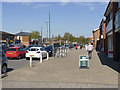
6
Bramcote Lane shops
These are on the north side of the road; there are other shops on the opposite side Image
Image: © Stephen Craven
Taken: 19 Jan 2020
0.18 miles
8
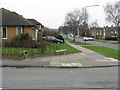
Rivergreen Crescent
Looking north-east at its junction with Thoresby Road.
Image: © M J Richardson
Taken: 3 Mar 2011
0.21 miles
9
Bramcote Lane Shops
A thriving local shopping centre with an excellent variety of retail outlets.
Image: © Alan Murray-Rust
Taken: 16 Apr 2014
0.21 miles
10
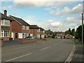
Deddington Lane
Archetypal post-war suburbia.
Image: © Alan Murray-Rust
Taken: 17 Oct 2016
0.21 miles