IMAGES TAKEN NEAR TO
Grangewood Road, NOTTINGHAM, NG8 2SA
Introduction
This page details the photographs taken nearby to Grangewood Road, NG8 2SA by members of the Geograph project.
The Geograph project started in 2005 with the aim of publishing, organising and preserving representative images for every square kilometre of Great Britain, Ireland and the Isle of Man.

There are currently over 7.5m images from over14,400 individuals and you can help contribute to the project by visiting https://www.geograph.org.uk
Image Map
Images are licensed for reuse under creativecommons.org/licenses/by-sa/2.0
Notes
- Clicking on the map will re-center to the selected point.
- The higher the marker number, the further away the image location is from the centre of the postcode.
Image Listing (32 Images Found)
Images are licensed for reuse under creativecommons.org/licenses/by-sa/2.0
Image
Details
Distance
1
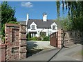
Model Cottage, Bramcote Lane
Until the coming of major housing development in the area, this was the only house between Wollaton village and Bramcote village.
The name derives from its relationship to Model Farm, which was located in a rectangle bounded by Wollaton Vale, Grangewood Road and Edlington Drive.
Image: © Alan Murray-Rust
Taken: 18 Sep 2016
0.04 miles
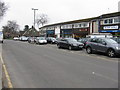
2
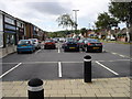
Local shops at Bramcote Hills
On Bramcote Lane.
Image: © M J Richardson
Taken: 3 Mar 2011
0.06 miles
3
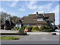
Hemlock Stone Public House, Wollaton
The pub takes its name from an unusual rock outcrop Image a couple of miles away.
Image: © Garth Newton
Taken: 9 Mar 2003
0.06 miles
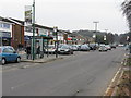
5
Bramcote Lane Shopping Parade
The shops are situated on both sides of the road, with car parking in front. Unlike many other similar areas this parade still has many proper shops (butchers, bakers, newsagent, post office, hardware store, etc), rather than the ubiquitous banks, estate agents, and betting shops.
Image: © Oxymoron
Taken: 10 Aug 2008
0.06 miles
6
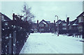
Redwood Avenue, Wollaton
Seen here on a snowy winter's day at the beginning of 1968, the houses here date from the mid-1950s, forming part of what was originally called the Model Farm Estate (on whose land they were built).
Image: © Stephen McKay
Taken: Unknown
0.07 miles
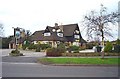
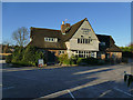
7
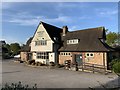
Hemlock Stone public house
Built in the late 1950s or early 1960s.
Image: © Andrew Abbott
Taken: 24 Apr 2020
0.08 miles
8
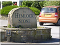
Inn sign with a difference
Created from a large piece of local stone. See http://www.geograph.org.uk/photo/3938666
Image: © Alan Murray-Rust
Taken: 16 Apr 2014
0.08 miles
9
The Hemlock Stone and Dragon
A large post-WW2 roadhouse type pub on Wollaton Vale. The Hemlock stone is a local outcrop feature http://www.geograph.org.uk/photo/622249 . The Dragon element of the name is a recent addition to promote its Asian cuisine.
Image: © Alan Murray-Rust
Taken: 16 Apr 2014
0.09 miles
10
The Hemlock Stone pub, Wollaton
The pub's name refers to a geological feature a couple of miles away Image For a view from a different direction, see Image
Image: © Stephen Craven
Taken: 19 Jan 2020
0.09 miles