IMAGES TAKEN NEAR TO
Vines Cross, NOTTINGHAM, NG8 2RU
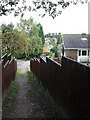
Introduction
This page details the photographs taken nearby to Vines Cross, NG8 2RU by members of the Geograph project.
The Geograph project started in 2005 with the aim of publishing, organising and preserving representative images for every square kilometre of Great Britain, Ireland and the Isle of Man.

There are currently over 7.5m images from over14,400 individuals and you can help contribute to the project by visiting https://www.geograph.org.uk
Image Map
Images are licensed for reuse under creativecommons.org/licenses/by-sa/2.0
Notes
- Clicking on the map will re-center to the selected point.
- The higher the marker number, the further away the image location is from the centre of the postcode.
Image Listing (30 Images Found)
Images are licensed for reuse under creativecommons.org/licenses/by-sa/2.0
Image
Details
Distance
1
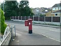
Woodbank Drive postbox NG8 478
Standard EIIR pillar box, with attached drop box. The pillar box red paint has rather faded.
The road, Vines Cross, is part of the Robin Hood Way long distance path. There is quite a long urban section between Wollaton Park and Bramcote Hills.
Image: © Alan Murray-Rust
Taken: 18 Sep 2016
0.02 miles
2
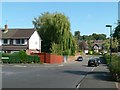
Woodbank Drive looking towards Wollaton Vale
The dip in the road marks the point at which it crosses the Tottle Brook http://www.geograph.org.uk/photo/5123314
This end of the road also forms part of the Robin Hood Way long distance footpath.
Image: © Alan Murray-Rust
Taken: 18 Sep 2016
0.05 miles
3
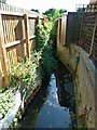
Tottle Brook at Woodbank Drive
Once a rural stream, it has been hemmed in by the gardens of later residential development, but remains largely unculverted.
Image: © Alan Murray-Rust
Taken: 18 Sep 2016
0.06 miles
4

Access to the Tottle Brook on Woodbank Drive
The rather menacing fence and gate provides access for keeping the brook clear of debris which could otherwise result in flooding of adjacent properties.
Image: © Alan Murray-Rust
Taken: 18 Sep 2016
0.06 miles
5
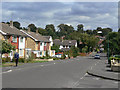
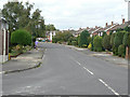
Woodbank Drive
Typical 1950s/60s suburban development.
Image: © Alan Murray-Rust
Taken: 6 Sep 2009
0.08 miles
6
Robin Hood Way
Link footpath out of Kingsdown Mount onto Bramcote Hills. Although marked on the OS maps, this section of the route is not waymarked or signposted and is difficult to follow even from the 1:25000 map.
Image: © Alan Murray-Rust
Taken: 6 Sep 2009
0.08 miles
7
Wroxham Drive
Typical 1950s/60s suburban development.
Image: © Alan Murray-Rust
Taken: 6 Sep 2009
0.09 miles
8
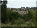
View from Bramcote Hills
Looking over Wollaton Vale, a large area of suburban development dating from the 1930s to the 1960s.
Image: © Alan Murray-Rust
Taken: 6 Sep 2009
0.09 miles
9
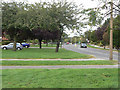
Wollaton Vale
Although not classified this is an important cut through round the west of Nottingham.
Image: © Alan Murray-Rust
Taken: 6 Sep 2009
0.10 miles
10
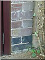
Bench mark, 137 Wollaton Vale
Close up view obtained courtesy of the owners.
Image: © Alan Murray-Rust
Taken: 18 Sep 2016
0.11 miles