IMAGES TAKEN NEAR TO
Wadhurst Grove, NOTTINGHAM, NG8 2RJ
Introduction
This page details the photographs taken nearby to Wadhurst Grove, NG8 2RJ by members of the Geograph project.
The Geograph project started in 2005 with the aim of publishing, organising and preserving representative images for every square kilometre of Great Britain, Ireland and the Isle of Man.

There are currently over 7.5m images from over14,400 individuals and you can help contribute to the project by visiting https://www.geograph.org.uk
Image Map
Images are licensed for reuse under creativecommons.org/licenses/by-sa/2.0
Notes
- Clicking on the map will re-center to the selected point.
- The higher the marker number, the further away the image location is from the centre of the postcode.
Image Listing (38 Images Found)
Images are licensed for reuse under creativecommons.org/licenses/by-sa/2.0
Image
Details
Distance
1
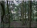
Alexandrina Plantation
On the north scarp of Bramcote Hills, a sandstone outcrop which has avoided being built over due to the steep slope here. The woodland cover consists principally of oak and birch.
Image: © Alan Murray-Rust
Taken: 6 Sep 2009
0.03 miles
2
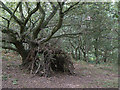
Tree House
In the Alexandrina Plantation on Bramcote Hill. The woodland cover consists principally of oak and birch.
Image: © Alan Murray-Rust
Taken: 6 Sep 2009
0.11 miles
3
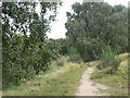
On Bramcote Hills
Part of the Alexandrina Plantation Nature Reserve. This is still a remarkably unspoilt area in the middle of suburban housing development, with natural vegetation. It lies on the sandstone outcrop of Bramcote Hills, and the sandy nature of the soil is shown by some typical vegetation - broom and birch. The sandy soil is clear too from the footpath.
Image: © Alan Murray-Rust
Taken: 6 Sep 2009
0.11 miles
5
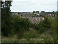
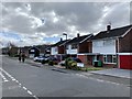
View from Bramcote Hills
Looking over Wollaton Vale, a large area of suburban development dating from the 1930s to the 1960s.
Image: © Alan Murray-Rust
Taken: 6 Sep 2009
0.12 miles
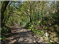
7
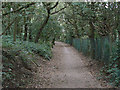
Sandy Lane
This was historically the direct link between Wollaton and Bramcote, and retains its bridleway status. Road traffic now makes the journey by means of the extension of Bramcote Lane as Thoresby Road.
Image: © Alan Murray-Rust
Taken: 6 Sep 2009
0.14 miles
8
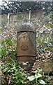
Old Boundary Marker on Alexandrina Plantation, Bramcote
Municipal Boundary Marker at the top of a steep slope, against a wire fence in Alexandrina Plantation Local Nature Reserve, off Sandy Lane in Bramcote. This marks the City of Nottingham boundary which absorbed Wollaton parish in 1933. See also https://www.geograph.org.uk/photo/3939857.
Milestone Society National ID: NT_NOT26pb
Image: © N Osmond
Taken: Unknown
0.14 miles
9
Sandy Lane, Bramcote Hills
An old established trackway through Bramcote Hills linking Beeston and Wollaton, here cutting through the Bunter sandstone of the scarp.
Image: © Alan Murray-Rust
Taken: 16 Apr 2014
0.14 miles
10
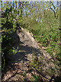
Rock outcrop, Alexandrina Plantation, Bramcote Hills
The hills are an escarpment of Bunter Sandstone which outcrops in several places. The area is now a nature reserve.
Image: © Alan Murray-Rust
Taken: 16 Apr 2014
0.14 miles