IMAGES TAKEN NEAR TO
Bramcote Lane, NOTTINGHAM, NG8 2NA
Introduction
This page details the photographs taken nearby to Bramcote Lane, NG8 2NA by members of the Geograph project.
The Geograph project started in 2005 with the aim of publishing, organising and preserving representative images for every square kilometre of Great Britain, Ireland and the Isle of Man.

There are currently over 7.5m images from over14,400 individuals and you can help contribute to the project by visiting https://www.geograph.org.uk
Image Map
Images are licensed for reuse under creativecommons.org/licenses/by-sa/2.0
Notes
- Clicking on the map will re-center to the selected point.
- The higher the marker number, the further away the image location is from the centre of the postcode.
Image Listing (156 Images Found)
Images are licensed for reuse under creativecommons.org/licenses/by-sa/2.0
Image
Details
Distance
1
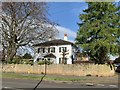
50 Bramcode Lane, Wollaton
A large house in Wollaton
Image: © Andrew Abbott
Taken: 19 Apr 2020
0.05 miles
2
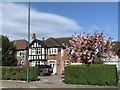
40 Bramcote Lane, Wollaton
1930s semi detached house with extension.
Image: © Andrew Abbott
Taken: 19 Apr 2020
0.05 miles
3
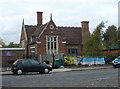
Wollaton School
Now converted to a day nursery.
Image: © Alan Murray-Rust
Taken: 19 Oct 2008
0.05 miles
4
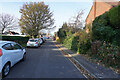
Smythson Drive
Smythson Drive may be being used as an unofficial car park for people wishing to go in Wollaton Deer Park.
Image: © Malcolm Neal
Taken: 25 Nov 2021
0.06 miles
5
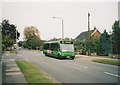
Bus on Bramcote Lane, Wollaton
Nottingham City Transport 246, an Optare Solo M920, trundles along Bramcote Lane while working route 193 to Beeston. This route was renumbered L10 in 2008 to reflect its status as one of the Locallink routes funded by Nottingham City Council.
Image: © Richard Vince
Taken: 6 Oct 2007
0.08 miles
6
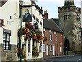
Wollaton
Although nowadays submerged in Nottingham's western suburbs, Wollaton village still has a rural feel to it, helped by its proximity to Wollaton Park and its status as a conservation area.
Image: © Stephen McKay
Taken: 3 Sep 2006
0.08 miles
7
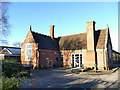
Busy Bees nursery, Wollaton
A school is shown here on the 1900 map, and this looks like the original building, adapted with a new entrance and modern extension behind.
Image: © Stephen Craven
Taken: 19 Jan 2020
0.08 miles
8
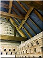
Wollaton Dovecote interior, upper floor
Showing the nesting holes built into the wall and the timber framing of the roof. The nesting holes are L-shaped to provide a partially enclosed nesting space. Listed Grade II.
Image: © Alan Murray-Rust
Taken: 12 Sep 2021
0.08 miles
9
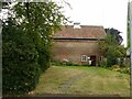
Wollaton Dovecote
Built 1585 for Sir Francis Willoughby of Wollaton Hall, altered early C19, restored 1987. Owned by Nottingham City Council and now leased to the Wollaton Historical & Conservation Society who run it as a small local museum. With a central dividing wall, it contains over 1000 nest holes and as dovecotes go would be considered substantially larger than average. Listed Grade II.
Part of the ground floor has been adapted to show a traditional cottage parlour and scullery of the period 1850-1950 http://www.geograph.org.uk/photo/6962128
Image: © Alan Murray-Rust
Taken: 12 Sep 2021
0.08 miles
10
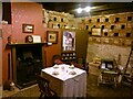
Wollaton Dovecote interior, ground floor
Part of the ground floor, adapted by the Wollaton Historical & Conservation Society who run the museum to show a traditional cottage parlour and scullery of the period 1850-1950; the building was never used for residential accommodation, although it was used as a stable at one time. Listed Grade II. The museum is generally open once a month and has varying displays on the upper floor.
Image: © Alan Murray-Rust
Taken: 12 Sep 2021
0.08 miles