IMAGES TAKEN NEAR TO
Wollaton Vale, NOTTINGHAM, NG8 2GP
Introduction
This page details the photographs taken nearby to Wollaton Vale, NG8 2GP by members of the Geograph project.
The Geograph project started in 2005 with the aim of publishing, organising and preserving representative images for every square kilometre of Great Britain, Ireland and the Isle of Man.

There are currently over 7.5m images from over14,400 individuals and you can help contribute to the project by visiting https://www.geograph.org.uk
Image Map
Images are licensed for reuse under creativecommons.org/licenses/by-sa/2.0
Notes
- Clicking on the map will re-center to the selected point.
- The higher the marker number, the further away the image location is from the centre of the postcode.
Image Listing (21 Images Found)
Images are licensed for reuse under creativecommons.org/licenses/by-sa/2.0
Image
Details
Distance
1
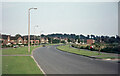
Wollaton Vale
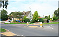
Inevitably in the intervening half century there have been many changes to this scene where Wollaton Vale approaches its junction with Bramcote Lane. Mature trees now occupy the grassed area on the left but more important changes have taken place on the right. A row of two storey flats was built shortly after this photograph was taken and beyond that there is now a health centre. The petrol station has survived but has been completely rebuilt, now incorporating an M&S Simply Food outlet.
Image: © Stephen McKay
Taken: Unknown
0.08 miles
2
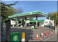
Wollaton filling station
On Wollaton Vale
Image: © Andrew Abbott
Taken: 24 Apr 2020
0.14 miles
3
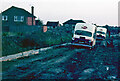
Humberstone Road, Wollaton
The quality of this old colour slide is far from ideal but the scene is of interest. At the time Humberstone Road was being built and, as was often the case in those days around building sites, no attempt was made to give the new roads a temporary surface, resulting in a quagmire after rain. On this summer evening in 1969 the driver of an ice cream van had, for some inexplicable reason, attempted to bring his vehicle this way. The inevitable happened and he got hopelessly stuck in the mud (and he couldn't even blame the SatNav!). He must somehow have contacted his company because they sent out another identical van to tow him out. Unfortunately the plan failed miserably when the second van got just as stuck as the first.
As an 11-year old witnessing this spectacular display of adult incompetence I, of course, found the whole thing hysterical and rushed home to get my camera. By the time I got back the light was fading but I got the shot (I imagine now that the two drivers were less than pleased to have an irritating kid around doubled up with laughter and taking a photograph). How the situation was eventually resolved is lost to history but I seem to recall they had gone by morning.
Image: © Stephen McKay
Taken: Unknown
0.15 miles
5
The Hemlock Stone
Recently refurbished, not yet tried it out but certainly looks nice.
Image: © David Lally
Taken: 28 Aug 2008
0.17 miles
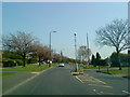
6
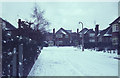
Redwood Avenue, Wollaton
Seen here on a snowy winter's day at the beginning of 1968, the houses here date from the mid-1950s, forming part of what was originally called the Model Farm Estate (on whose land they were built).
Image: © Stephen McKay
Taken: Unknown
0.18 miles
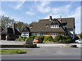
7
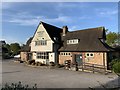
Hemlock Stone public house
Built in the late 1950s or early 1960s.
Image: © Andrew Abbott
Taken: 24 Apr 2020
0.18 miles
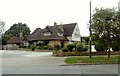
8
The Hemlock Stone pub, Wollaton
The pub's name refers to a geological feature a couple of miles away Image For a view from a different direction, see Image
Image: © Stephen Craven
Taken: 19 Jan 2020
0.18 miles
9
The Hemlock Stone and Dragon
A large post-WW2 roadhouse type pub on Wollaton Vale. The Hemlock stone is a local outcrop feature http://www.geograph.org.uk/photo/622249 . The Dragon element of the name is a recent addition to promote its Asian cuisine.
Image: © Alan Murray-Rust
Taken: 16 Apr 2014
0.19 miles
10
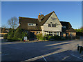
Hemlock Stone Public House, Wollaton
Recreating this 'First' for the square http://www.geograph.org.uk/photo/17069 .
The weatherboarding has a different colour and the inn sign in the middle of the car park entrance has been removed.
Image: © Alan Murray-Rust
Taken: 18 Aug 2021
0.19 miles