IMAGES TAKEN NEAR TO
Courtney Close, NOTTINGHAM, NG8 2BS
Introduction
This page details the photographs taken nearby to Courtney Close, NG8 2BS by members of the Geograph project.
The Geograph project started in 2005 with the aim of publishing, organising and preserving representative images for every square kilometre of Great Britain, Ireland and the Isle of Man.

There are currently over 7.5m images from over14,400 individuals and you can help contribute to the project by visiting https://www.geograph.org.uk
Image Map
Images are licensed for reuse under creativecommons.org/licenses/by-sa/2.0
Notes
- Clicking on the map will re-center to the selected point.
- The higher the marker number, the further away the image location is from the centre of the postcode.
Image Listing (32 Images Found)
Images are licensed for reuse under creativecommons.org/licenses/by-sa/2.0
Image
Details
Distance
1
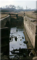
Nottingham Canal Wollaton Flight
About halfway down the flight of locks on the Nottingham Canal, looking towards the summit level, in 1963.The exact date of the shot is not known other than the year.
Image: © Richard Bird
Taken: 20 Apr 1963
0.04 miles
2
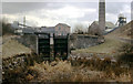
Nottingham Canal and Colliery 1963
Accessed by way of Woodyard Lane, the Nottingham Canal climbed by a succession of locks to reach its summit level close by Wollaton Colliery. At this time, in 1963, many of the lock gates had been vandalised and many were missing. Today, it is hard to comprehend that this scene existed, since now the area has been covered by modern housing.
Image: © Richard Bird
Taken: 21 Mar 1963
0.06 miles
4
A walk round Martin's Pond (9)
To the west of the nature reserve is a large area of allotment gardens, all bounded by fences and hedges which are marked on the 1:25000 OS map. This view is looking west through the fence between the allotments and Martin's Pond nature reserve.
Previous image: Image, next image: Image
Image: © Kate Jewell
Taken: 11 Mar 2008
0.15 miles
5
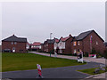
New houses, Martin's Reach, Wollaton
A new development by Avant Homes on the former allotments off Russell Drive.
Image: © SK53
Taken: 4 Jan 2019
0.16 miles
6
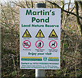
A walk round Martin's Pond (8)
Enjoy your visit? . . . If you dare!
This sign in the wooded north west corner of the nature reserve reminds visitors to respect both their own safety and that of the environment while still inviting them to enjoy themselves. Note how close the urban sprawl is, just visible through the trees.
See http://www.nottinghamcity.gov.uk/www/greenspaces/Docs/MartinsPondmap.pdf for a map of the site.
Previous image: Image, next image: Image
Image: © Kate Jewell
Taken: 11 Mar 2008
0.17 miles
7
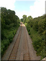
Railway Line Looking West
I'm not sure what services now use this line, in the days of British Rail trains from Sheffield to St Pancras via Nottingham came this way.
To the west of here this will join the Erewash Valley Line http://en.wikipedia.org/wiki/Erewash_Valley_Line just south of Trowell.
Image: © David Lally
Taken: 16 Jun 2009
0.18 miles
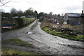
8
Access road to Martin's Reach
Martin's Reach is a new housing development off Russell Drive in Wollaton village. It largely occupies the site of former allotments next to Martin's Pond (hence part of the name).
Image: © SK53
Taken: 4 Jan 2019
0.18 miles
9
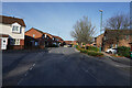
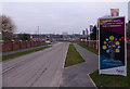
Torvill Drive
Torvill Drive is a long and meandering road to the north of Russell Drive. I presume it is named after the ice dancer who won an Olympic gold medal in the 1980's.
Image: © Malcolm Neal
Taken: 25 Nov 2021
0.19 miles
10
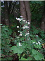
Canadian Fleabane
An attractive introduced member of the compositae, in scrub woodland surrounding Martins Pond.
Image: © Alan Murray-Rust
Taken: 19 Oct 2008
0.20 miles