IMAGES TAKEN NEAR TO
Russell Drive, NOTTINGHAM, NG8 2BE
Introduction
This page details the photographs taken nearby to Russell Drive, NG8 2BE by members of the Geograph project.
The Geograph project started in 2005 with the aim of publishing, organising and preserving representative images for every square kilometre of Great Britain, Ireland and the Isle of Man.

There are currently over 7.5m images from over14,400 individuals and you can help contribute to the project by visiting https://www.geograph.org.uk
Image Map
Images are licensed for reuse under creativecommons.org/licenses/by-sa/2.0
Notes
- Clicking on the map will re-center to the selected point.
- The higher the marker number, the further away the image location is from the centre of the postcode.
Image Listing (202 Images Found)
Images are licensed for reuse under creativecommons.org/licenses/by-sa/2.0
Image
Details
Distance
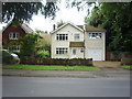
1
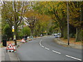
Russell Drive
Created in the 1930s to bypass the narrow lane through Wollaton Village.
Image: © Alan Murray-Rust
Taken: 19 Oct 2008
0.02 miles
2

Advertising Hoarding for new housing development
Martin's Reach is being built by Avant Homes on the former allotment site adjacent to Martin's Pond. The access road follows the same line as the original track into the allotment site, but has been widened through demolition of a house on the W side.
Image: © SK53
Taken: 4 Jan 2019
0.02 miles
3

Martin's Reach
A new housing development by Avant Homes.
Image: © Andrew Abbott
Taken: 19 May 2020
0.02 miles
4
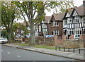
1930s suburbia, Wollaton
Houses along Russell Drive with tudorbethan embellishment.
Image: © Alan Murray-Rust
Taken: 19 Oct 2008
0.04 miles
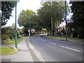
5
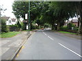
Bus stop on Russell Drive, Wollaton
Looking east.
Image: © JThomas
Taken: 9 Jul 2016
0.05 miles
6
Pond Way, Wollaton
The entry to Martin's Reach housing development on an area formerly occupied by allotment gardens.
Image: © Alan Murray-Rust
Taken: 3 Aug 2021
0.05 miles
8
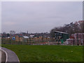
Replacement Allotments, Martin's Reach
A much reduced area of allotments was included in the Martin's Reach development. These must have been re-occupied very recently and look rather different from their predecessor. A small stream runs through the allotments and then into Martin's Pond Local Nature Reserve (the trees rear right) and from thence into Harrison's Plantation.
See https://www.geograph.org.uk/photo/728465 for a view of the old allotments.
Image: © SK53
Taken: 4 Jan 2019
0.05 miles
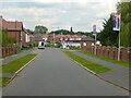
9
Russell Drive, Wollaton
Russell Drive provides a direct route for the A609 between Nottingham and Ilkeston, bypassing Wollaton old village, and serves typical 1930s suburban housing.
Image: © Richard Vince
Taken: 15 Sep 2012
0.05 miles
10
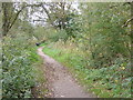
Footpath around Martins Pond
Apparently developed as a fish pond, probably in the middle of the 18th century, connected with Wollaton Hall. It is now a valuable wildlife habitat.
Image: © Alan Murray-Rust
Taken: 19 Oct 2008
0.05 miles