IMAGES TAKEN NEAR TO
Russell Drive, NOTTINGHAM, NG8 2BA
Introduction
This page details the photographs taken nearby to Russell Drive, NG8 2BA by members of the Geograph project.
The Geograph project started in 2005 with the aim of publishing, organising and preserving representative images for every square kilometre of Great Britain, Ireland and the Isle of Man.

There are currently over 7.5m images from over14,400 individuals and you can help contribute to the project by visiting https://www.geograph.org.uk
Image Map (Loading...)


Getting Data...Please wait
Leaflet Map data © OpenStreetMap
Images are licensed for reuse under creativecommons.org/licenses/by-sa/2.0
Notes
- Clicking on the map will re-center to the selected point.
- The higher the marker number, the further away the image location is from the centre of the postcode.
Image Listing (145 Images Found)
Images are licensed for reuse under creativecommons.org/licenses/by-sa/2.0
Image
Details
Distance
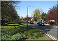
1
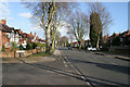
Russell Drive
Looking east towards Nottingham city centre along the A609, a busy exit route from Nottingham. This tree lined road looks very quiet at 4.30 pm but just you wait until 5 o'clock! The road to the left is Russell Avenue which gives access to Martin's Pond Nature Reserve: http://www.geograph.org.uk/photo/728288
Image: © Kate Jewell
Taken: 11 Mar 2008
0.03 miles
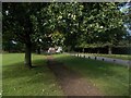
2
A walk round Martin's Pond (15)
Russell Avenue from the gate into the Nature Reserve: the end of our walk.
See http://www.nottinghamcity.gov.uk/www/greenspaces/Docs/MartinsPondmap.pdf for a map of the site.
Previous image: Image
Image: © Kate Jewell
Taken: 11 Mar 2008
0.06 miles
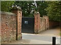
3
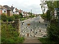
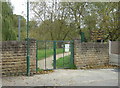
The entrance to Martin's Pond
The new gates were installed in July 2020; created with local children from Fernwood School and Artist Richard Janes.
Image: © Alan Murray-Rust
Taken: 3 Aug 2021
0.09 miles
5
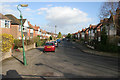
Wollaton Road on a May morning
Looking towards the village from just outside the main northern entrance to Wollaton Park. The Park's perimeter wall is on the left.
Image: © John Sutton
Taken: 4 May 2016
0.10 miles
6
Wollaton Park Nottingham
Gate onto Wollaton Road
Image: © norman griffin
Taken: 19 Sep 2017
0.10 miles
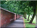
7
Wollaton Park, boundary wall and gates
The principal section of the wall on the north side of the park, alongside Wollaton Road, Listed Grade II. The wall dates from the late 18th century, with gateways broken through at various times in the late 19th and 20th centuries.
Image: © Alan Murray-Rust
Taken: 12 Sep 2021
0.10 miles
8
Wollaton Park wall
The 7m/11k-long brick wall circling Wollaton Park dates from the early years of the 19th century. Large parts of it still stand, including this stretch seen from outside the Wollaton Road entrance to the park.
Image: © John Sutton
Taken: 22 Jun 2011
0.11 miles
9
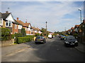
The entrance to Martins Pond
A valuable natural reserve surrounded by housing developments.
Image: © Alan Murray-Rust
Taken: 19 Oct 2008
0.11 miles
10
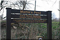
A walk round Martin's Pond, Wollaton (Introduction)
Martin's Pond is a bio-diverse 4 hectare site on the western side of the city of Nottingham. It is important because it is an example of Natural Succession demonstrating varied habitats, (see http://www.bgs.ac.uk/eqr/Nat_Succession.htm for an explanation of this). The Nature Reserve, which was created in 1974, is managed to retain the status quo and is thus home to a wide variety of species.
See http://www.nottinghamcity.gov.uk/www/greenspaces/martinspond.asp for more information and a down loadable map.
Follow the sequence of images to join me in my walk round the pond.
Next image:Image
Image: © Kate Jewell
Taken: 11 Mar 2008
0.11 miles