IMAGES TAKEN NEAR TO
Tranby Gardens, NOTTINGHAM, NG8 2AB
Introduction
This page details the photographs taken nearby to Tranby Gardens, NG8 2AB by members of the Geograph project.
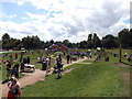
The Geograph project started in 2005 with the aim of publishing, organising and preserving representative images for every square kilometre of Great Britain, Ireland and the Isle of Man.

There are currently over 7.5m images from over14,400 individuals and you can help contribute to the project by visiting https://www.geograph.org.uk
Image Map
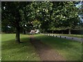
Images are licensed for reuse under creativecommons.org/licenses/by-sa/2.0
Notes
- Clicking on the map will re-center to the selected point.
- The higher the marker number, the further away the image location is from the centre of the postcode.
Image Listing (216 Images Found)
Images are licensed for reuse under creativecommons.org/licenses/by-sa/2.0
Image
Details
Distance
1
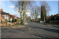
Russell Drive
Looking east towards Nottingham city centre along the A609, a busy exit route from Nottingham. This tree lined road looks very quiet at 4.30 pm but just you wait until 5 o'clock! The road to the left is Russell Avenue which gives access to Martin's Pond Nature Reserve: http://www.geograph.org.uk/photo/728288
Image: © Kate Jewell
Taken: 11 Mar 2008
0.06 miles
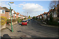
2
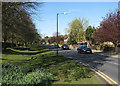
Wollaton Road on a May morning
Looking towards the village from just outside the main northern entrance to Wollaton Park. The Park's perimeter wall is on the left.
Image: © John Sutton
Taken: 4 May 2016
0.07 miles
3
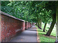
Wollaton Park wall
The 7m/11k-long brick wall circling Wollaton Park dates from the early years of the 19th century. Large parts of it still stand, including this stretch seen from outside the Wollaton Road entrance to the park.
Image: © John Sutton
Taken: 22 Jun 2011
0.08 miles
4
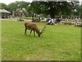
Red deer stag grazing in Wollaton Park
This individual is clearly very habituated to human presence, and continued grazing even when some children approached within a couple of metres of him. In general the deer herds (red and fallow) do not come into this area.
Image: © Alan Murray-Rust
Taken: 12 Sep 2021
0.10 miles
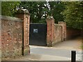
5
Wollaton Park Nottingham
Gate onto Wollaton Road
Image: © norman griffin
Taken: 19 Sep 2017
0.10 miles
6
Wollaton Park, boundary wall and gates
The principal section of the wall on the north side of the park, alongside Wollaton Road, Listed Grade II. The wall dates from the late 18th century, with gateways broken through at various times in the late 19th and 20th centuries.
Image: © Alan Murray-Rust
Taken: 12 Sep 2021
0.10 miles
7
A walk round Martin's Pond (15)
Russell Avenue from the gate into the Nature Reserve: the end of our walk.
See http://www.nottinghamcity.gov.uk/www/greenspaces/Docs/MartinsPondmap.pdf for a map of the site.
Previous image: Image
Image: © Kate Jewell
Taken: 11 Mar 2008
0.11 miles
8
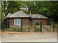
Wollaton Park, No.1 Lodge, Wollaton Road
Early 19th century, originally just the left hand section, the wing to the right added in the 1950s. Listed Grade II.
Image: © Alan Murray-Rust
Taken: 12 Sep 2021
0.11 miles
10
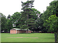
Wollaton Park: the last of the POW huts
From 1945-8 the northern part of the park was covered with huts housing German prisoners of war. Most were quickly removed, but four just inside the Wollaton Road entrance survived long enough to be used as changing rooms for school cross-country runners (including me) and footballers in the 1960s, and for some time afterwards. This is the only one still standing.
Image: © John Sutton
Taken: 22 Jun 2011
0.11 miles