IMAGES TAKEN NEAR TO
Harris Close, NOTTINGHAM, NG8 1GE
Introduction
This page details the photographs taken nearby to Harris Close, NG8 1GE by members of the Geograph project.
The Geograph project started in 2005 with the aim of publishing, organising and preserving representative images for every square kilometre of Great Britain, Ireland and the Isle of Man.

There are currently over 7.5m images from over14,400 individuals and you can help contribute to the project by visiting https://www.geograph.org.uk
Image Map
Images are licensed for reuse under creativecommons.org/licenses/by-sa/2.0
Notes
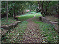
- Clicking on the map will re-center to the selected point.
- The higher the marker number, the further away the image location is from the centre of the postcode.
Image Listing (90 Images Found)
Images are licensed for reuse under creativecommons.org/licenses/by-sa/2.0
Image
Details
Distance
1
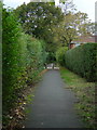
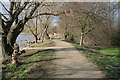
Old Coach Road
Now a pedestrian route linking Wollaton with Beechdale and Bilborough. The bollards mark the crossing with Grantleigh Close.
Image: © Alan Murray-Rust
Taken: 19 Oct 2008
0.03 miles
2
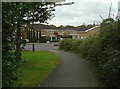
Grantleigh Close
Unusually for a modern development, this close is split in two, as far as road access is concerned. The continuity is maintained by this pedestrian and cycle way, which has been provided with profiled blocks which permit the passage of emergency vehicles.
Image: © Alan Murray-Rust
Taken: 19 Oct 2008
0.03 miles
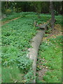
3
Nottingham Canal remains
Until the 1980s there was a considerable stretch of the old Nottingham Canal extant in this area. Most was built over, but this section containing the remains of two locks and two intermediate pounds was retained as open space. The locks were a substantial flight with closely spaced locks separated by generally elliptical pounds to help maintain water levels. The entrance to a lock can be seen to the right of the light tree, and to the left of it is the overflow weir with its curved cill.
Image: © Alan Murray-Rust
Taken: 19 Oct 2008
0.07 miles
4
Lock weir
The curved stonework is the cill of the overflow past one of the locks on the old Nottingham Canal. The lock itself was just beyond it.
Image: © Alan Murray-Rust
Taken: 19 Oct 2008
0.07 miles
5
Nottingham Canal locks
Looking from the lower lock up to the higher of the remaining pair.
Image: © Alan Murray-Rust
Taken: 19 Oct 2008
0.08 miles
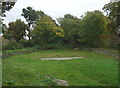
6
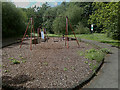
Lambourne Drive Playground
Looking decidedly run-down.
Image: © David Lally
Taken: 16 Jun 2009
0.08 miles
7
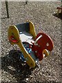
Rocking Chicken?
In Lambourne Drive playground.
Image: © David Lally
Taken: 16 Jun 2009
0.08 miles
8
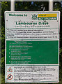
Welcome, with Provisos
Setting out the City of Nottingham "Playground Charter".
Image: © David Lally
Taken: 16 Jun 2009
0.08 miles
9
A walk round Martin's Pond (4)
There is a well surfaced path all the way round the Pond. On the eastern side it is fairly open with scrubby woodland to the east and mature willows along the edge of the water. In the distance the path runs into marshy willow beds and is much more enclosed.
See http://www.nottinghamcity.gov.uk/www/greenspaces/Docs/MartinsPondmap.pdf for a map of the site.
Previous image: Image, next image: Image
Image: © Kate Jewell
Taken: 11 Mar 2008
0.08 miles
10
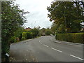
Lambourne Drive
1980s housing development, largely along the line of the old Nottingham Canal.
Image: © Alan Murray-Rust
Taken: 19 Oct 2008
0.10 miles