IMAGES TAKEN NEAR TO
Harrow Road, NOTTINGHAM, NG8 1FN
Introduction
This page details the photographs taken nearby to Harrow Road, NG8 1FN by members of the Geograph project.
The Geograph project started in 2005 with the aim of publishing, organising and preserving representative images for every square kilometre of Great Britain, Ireland and the Isle of Man.

There are currently over 7.5m images from over14,400 individuals and you can help contribute to the project by visiting https://www.geograph.org.uk
Image Map
Images are licensed for reuse under creativecommons.org/licenses/by-sa/2.0
Notes
- Clicking on the map will re-center to the selected point.
- The higher the marker number, the further away the image location is from the centre of the postcode.
Image Listing (43 Images Found)
Images are licensed for reuse under creativecommons.org/licenses/by-sa/2.0
Image
Details
Distance
1
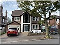
147 Harrow Road, Wollaton
Radical modernisation of a 1930s house.
Image: © Andrew Abbott
Taken: 19 May 2020
0.03 miles
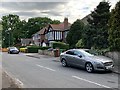
2

Harrow Road
Harrow Road is a residential street bounding the Northern edge of Wollaton Park. Comprising mainly detached houses constructed in the 1930s, it is a popular area in which to live.
Image: © Chris Edwards
Taken: Unknown
0.03 miles
3
Wollaton Road - Nottingham
Looking East towards Nottingham from the junction with Ancaster Gardens
Image: © David Lally
Taken: 29 Nov 2007
0.07 miles
4
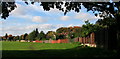
Patchwork fenceline
On the back gardens of the houses of Harrow Road, backing onto Wollaton Park.
Image: © David Lally
Taken: 9 Oct 2008
0.08 miles
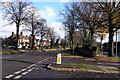
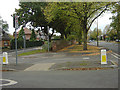
5
Traffic on Wollaton Road
City-bound traffic a little before nine o'clock on a bright May morning.
Image: © John Sutton
Taken: 4 May 2016
0.08 miles
6

Bay windows on Wollaton Road
Part of the big post-war westward expansion of the city.
Image: © John Sutton
Taken: 24 Aug 2017
0.09 miles
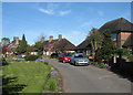
7
Ancaster Gardens, Wollaton
From the junction with Harrow Road.
Image: © Andrew Abbott
Taken: 19 May 2020
0.09 miles
8
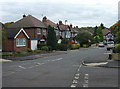
Ancaster Gardens, Wollaton
Part of the immediate pre-war development in the Wollaton area, this and neighbouring roads are within the old precincts of Wollaton Park. The land effectively became available after the Hall and Park were gifted to the City of Nottingham.
Image: © Alan Murray-Rust
Taken: 19 Oct 2008
0.10 miles
9
Wollaton: Derbyshire Crescent
A plaque reads "These memorial homes were erected by Lucy Derbyshire in memory of her husband Samuel Patrick and her son Harold Allison Derbyshire, July 1938".
Image: © John Sutton
Taken: 4 May 2016
0.13 miles
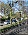
10
Wollaton Park wall
The housing to the left was developed inside the old boundary of Wollaton Park, as evidenced by the wall in centre shot. The address for the houses is Wollaton Road, which is the main road visible.
Image: © Alan Murray-Rust
Taken: 19 Oct 2008
0.14 miles