IMAGES TAKEN NEAR TO
Second Avenue, NOTTINGHAM, NG7 6JJ
Introduction
This page details the photographs taken nearby to Second Avenue, NG7 6JJ by members of the Geograph project.
The Geograph project started in 2005 with the aim of publishing, organising and preserving representative images for every square kilometre of Great Britain, Ireland and the Isle of Man.

There are currently over 7.5m images from over14,400 individuals and you can help contribute to the project by visiting https://www.geograph.org.uk
Image Map
Images are licensed for reuse under creativecommons.org/licenses/by-sa/2.0
Notes
- Clicking on the map will re-center to the selected point.
- The higher the marker number, the further away the image location is from the centre of the postcode.
Image Listing (220 Images Found)
Images are licensed for reuse under creativecommons.org/licenses/by-sa/2.0
Image
Details
Distance
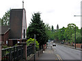
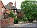
1
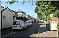
Sherwood Rise: Second Avenue
The grand villas on First, Second and Third Avenues were some of the first houses built north of The Forest as Nottingham expanded after the Enclosure Act of 1845. Subsequently smaller houses have been built on some of the large gardens.
Image: © John Sutton
Taken: 5 Sep 2013
0.03 miles
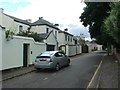

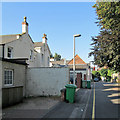
4
Sherwood Rise: outbuildings on Third Avenue
The grand villas on First, Second and Third Avenues were some of the first houses built north of The Forest as Nottingham expanded after the Enclosure Act of 1845. To the left of the picture are the backs of red-brick terraced houses on Wiverton Road, part of the Forest Fields development which happened after the parishes of Lenton, Radford and Basford became part of the Borough in 1877.
Image: © John Sutton
Taken: 5 Sep 2013
0.05 miles
5
Twentieth-century houses on First Avenue
These houses were built on what had been the large gardens of some of the substantial villas built c 1850-70, when First, Second and Third Avenues were established as some of the first part of the new suburb north of The Forest, part of the Borough's expansion after the Enclosure Act of 1845.
Image: © John Sutton
Taken: 5 Sep 2013
0.05 miles
6
Sherwood Rise: two churches
The Polish church is on the left and the Victorian spire of St Andrew's, on Mansfield Road, is on the horizon.
Image: © John Sutton
Taken: 27 Apr 2011
0.06 miles
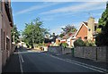
7
The corner of First Avenue and Sherwood Rise
First, Second and Third Avenues were some of the first suburban developments north of The Forest, with some substantial houses dating from c 1850-70, the period of the Borough's initial expansion after the Enclosure Act of 1845. The striking west front of the Polish Church of Our Lady of Czestochow is on the other side of Sherwood Rise.
Image: © John Sutton
Taken: 5 Sep 2013
0.06 miles
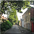
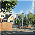
8
Near the end of Second Avenue
The grand villas on First, Second and Third Avenues were some of the first houses built north of The Forest as Nottingham expanded after the Enclosure Act of 1845. Subsequently smaller houses have been built on some of the large gardens (see Image]). In the distance on the right are the backs of red-brick terraced houses on Foxhall Road, built in the late 19th century as part of the Forest Fields development.
Image: © John Sutton
Taken: 5 Sep 2013
0.06 miles
9
The Turret House
Unmistakeably a product of local architect Watson Fothergill. Built in 1894.
Image: © Alan Murray-Rust
Taken: 27 Aug 2009
0.06 miles
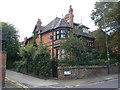
10
Watson Fothergill's 1 and 3 Sherwood Rise
The nearer of this grand semi-detached pair, on the corner of Third Avenue, is known as the Turret House. Fothergill's distinctive style - dark wood contrasting with Nottingham Patent Brick, tall chimneys, pointy towers and dormers with spiky finials - is at its more restrained here. The pair date from 1894. Fothergill's Image] is a little further up Sherwood Rise, on the corner of Berridge Road.
Image: © John Sutton
Taken: 27 Apr 2011
0.06 miles