IMAGES TAKEN NEAR TO
Knighton Avenue, NOTTINGHAM, NG7 5QD
Introduction
This page details the photographs taken nearby to Knighton Avenue, NG7 5QD by members of the Geograph project.
The Geograph project started in 2005 with the aim of publishing, organising and preserving representative images for every square kilometre of Great Britain, Ireland and the Isle of Man.

There are currently over 7.5m images from over14,400 individuals and you can help contribute to the project by visiting https://www.geograph.org.uk
Image Map
Images are licensed for reuse under creativecommons.org/licenses/by-sa/2.0
Notes
- Clicking on the map will re-center to the selected point.
- The higher the marker number, the further away the image location is from the centre of the postcode.
Image Listing (238 Images Found)
Images are licensed for reuse under creativecommons.org/licenses/by-sa/2.0
Image
Details
Distance
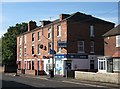
1

Woodstock Avenue
The road slopes down from Churchfield Lane to the River Leen. There are similar houses in nearby Kingsford and Knighton Avenues and on Churchfield Lane, all built in the late 1930s as the city expanded westwards beyond its Victorian and Edwardian edges.
Image: © John Sutton
Taken: 21 Jul 2012
0.03 miles
2
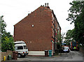
Bin men on Radford Grove Lane
In the 18th century Radford Grove Lane led down to Radford Folly, a fashionable pleasure garden by the banks of the Leen (see http://www.nottshistory.org.uk/whatnall1928/radford_folly.htm ). In the last century, the background of this view was dominated by the tall Players cigarette factory on the far side of Churchfield Lane, now demolished and the site of a retail park. The trees on the right are in Radford churchyard. Image] shows the Churchfield Lane end of this row of houses.
Image: © John Sutton
Taken: 12 Jul 2011
0.03 miles
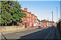
4
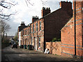
Knighton Avenue
The brown-brick houses on Knighton Avenue, Woodstock Avenue, Kingsford Avenue and the west side of Churchfield Lane are all of a piece, with these distinctive half-timbered gables.
Image: © John Sutton
Taken: 20 Nov 2009
0.04 miles
5
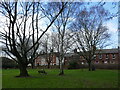
St Peter's Park, Radford
The former graveyard of St Peter's church.
Image: © Jonathan Thacker
Taken: 26 Feb 2024
0.05 miles
6
Churchfield News
It is indeed stationary - but sells stationery....
Image: © John Sutton
Taken: 20 Nov 2009
0.05 miles
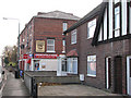
7
Churchfield News and Booze
A long-established newsagent's shop on the corner of a late-Victorian block. See Image] for a view of it in November 2009, before the Lifestyle Express branding. (There was no such thing as lifestyle fifty-odd years ago when my mother and I walked up Churchfield Lane every week to pay the paper bill.)
Image: © John Sutton
Taken: 13 Sep 2012
0.05 miles
8
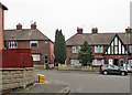
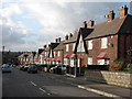
The corner of Woodstock Avenue and Kingsford Avenue
Streets of distinctively-gabled houses laid out in the 1930s as the city expanded westwards beyond its Victorian and Edwardian edges.
Image: © John Sutton
Taken: 20 Apr 2015
0.05 miles
9
On Churchfield Lane
St Peter's churchyard is to the left. This part of Churchfield Lane used to be shadowed at this time of the morning by the tall Player's tobacco factory on the right. Its site is now a retail park.
Image: © John Sutton
Taken: 25 Sep 2015
0.06 miles
10
River Leen at Bobbers Mill
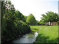
A friendly man walking his dog told me this area was "The Hidden Jewel of Bobbers Mill". It's hard to imagine that this tranquil spot was until the 1960s next to a busy colliery. Old photos of Radford Colliery show the concrete-post-and-iron-rail fence which now borders Maun Avenue. The streets of houses to the right were built in the 1970s on colliery and railway land. In the 18th century, though, this was Radford Grove http://www.nottshistory.org.uk/whatnall1928/radford_folly.htm , a fashionable pleasure garden, and Radford Folly, a stuccoed brick tower, survived in ruins into the 1950s, in a sea of colliery spoil.
Image: © John Sutton
Taken: 19 May 2010
0.07 miles