IMAGES TAKEN NEAR TO
Wades Avenue, NOTTINGHAM, NG7 5PJ
Introduction
This page details the photographs taken nearby to Wades Avenue, NG7 5PJ by members of the Geograph project.
The Geograph project started in 2005 with the aim of publishing, organising and preserving representative images for every square kilometre of Great Britain, Ireland and the Isle of Man.

There are currently over 7.5m images from over14,400 individuals and you can help contribute to the project by visiting https://www.geograph.org.uk
Image Map
Images are licensed for reuse under creativecommons.org/licenses/by-sa/2.0
Notes
- Clicking on the map will re-center to the selected point.
- The higher the marker number, the further away the image location is from the centre of the postcode.
Image Listing (185 Images Found)
Images are licensed for reuse under creativecommons.org/licenses/by-sa/2.0
Image
Details
Distance
1
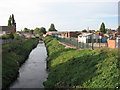
River Leen from Meadow Brown Road
Looking south towards where the original Bobbers Mill once stood.
Image: © John Sutton
Taken: 25 Sep 2009
0.02 miles
2
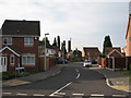
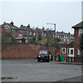
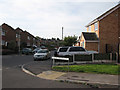
Wades Avenue
Part of the recent developments in the Plantation Side area of Bobbers Mill. Lindley & Lindley's chimney in the background is a reminder - for how much longer? - of the area's industrial past.
Image: © John Sutton
Taken: 25 Sep 2009
0.03 miles
3
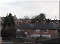
Bobbers Mill Panorama
This zoom view from the railway footbridge shows the houses of Darley Avenue in the foreground and beyond them the roofs of Chadwick Road (right) and Darley Road (left). St Stephen's Church on Bobbers Mill Road is on the horizon on the left and two of the Radford football ground's floodlights on the right. When I was a boy, this view was blocked by Bobbers Mill, long demolished.
Image: © John Sutton
Taken: 20 Nov 2009
0.05 miles
5
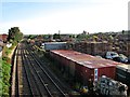
The Leen Valley at Bobbers Mill
The canalised and partly-culverted Leen runs behind DTN Pallets' yard, which occupies the site of the mill which gave the area its name. The Midland Railway line to Mansfield and Worksop was the first of three built to serve the Leen Valley's pits and the only one which remains. The chimney in the centre is all that remains of Gerard's Soap Works (demolished in April 2011); the former Shipstone's Brewery (Image]) is on the skyline to the right of centre. The view is from the footbridge: Image] is the view in the other direction.
Image: © John Sutton
Taken: 13 Sep 2012
0.05 miles
6
Plantation Side
The Darley Road end of the twitchel which winds through the former Lindley & Lindley site. The houses ahead are on the middle part of Plantation Side, which is a road.
Image: © John Sutton
Taken: 13 Sep 2012
0.06 miles
7
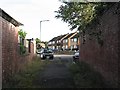
An overcast morning on Plantation Side
The southern end of Plantation Side (straight ahead) is a narrow twitchel between high brick walls - and once, further on, the buildings of Lindley & Lindley's hosiery works. The backs of houses on Chadwick Road are on the skyline. Like those of Darley Avenue on the right, they were built in the 1930s.
Image: © John Sutton
Taken: 11 Apr 2013
0.06 miles
8
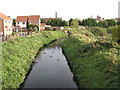
River Leen
Looking NNE from Meadow Brown Road, with Gerard's Soap Works ("INO") and Shipstone's Brewery in the distance.
Image: © John Sutton
Taken: 25 Sep 2009
0.06 miles
9
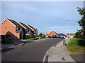
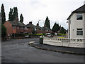
The corner of Meadow Brown Road and Plantation Side
Image: © John Sutton
Taken: 25 Sep 2009
0.07 miles
10
Plantation Side - 2
The corner of Plantation Side - now a suburban backstreet - and Darley Avenue.
Image: © John Sutton
Taken: 12 Aug 2009
0.07 miles