IMAGES TAKEN NEAR TO
Alfreton Road, NOTTINGHAM, NG7 5NJ
Introduction
This page details the photographs taken nearby to Alfreton Road, NG7 5NJ by members of the Geograph project.
The Geograph project started in 2005 with the aim of publishing, organising and preserving representative images for every square kilometre of Great Britain, Ireland and the Isle of Man.

There are currently over 7.5m images from over14,400 individuals and you can help contribute to the project by visiting https://www.geograph.org.uk
Image Map
Images are licensed for reuse under creativecommons.org/licenses/by-sa/2.0
Notes
- Clicking on the map will re-center to the selected point.
- The higher the marker number, the further away the image location is from the centre of the postcode.
Image Listing (210 Images Found)
Images are licensed for reuse under creativecommons.org/licenses/by-sa/2.0
Image
Details
Distance
1
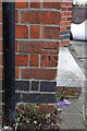
Benchmark on #545 Alfreton Road
Ordnance Survey cut mark benchmark described on the Bench Mark Database at http://www.bench-marks.org.uk/bm47877
Image: © Roger Templeman
Taken: 31 Mar 2013
0.01 miles
2
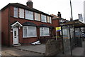
#545 Alfreton Road and Chadwick Road bus stop
There is an OS benchmark Image on the side of the house, right of the black downpipe.
Image: © Roger Templeman
Taken: 31 Mar 2013
0.01 miles
3
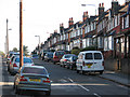
Bobbers Mill: Alfreton Road old and new
The tarmac in the foreground is Alfreton Road, which becomes Bobbers Mill Bridge where the slope begins on the left of the picture. Bobbers Mill Bridge, built in the late 1930s at the same time as Western Boulevard as the city expanded westwards, replaced the old Alfreton Road, straight ahead, where there was once a level crossing over the Nottingham-Mansfield railway. The houses on the right are the same design as others in the area and also date from the late 1930s. The former Lindley & Lindley factory shown in Image] is behind them.
Image: © John Sutton
Taken: 15 Sep 2011
0.02 miles
4
Lynmouth Crescent
Straight, with turning circles at their ends, neither Lynmouth Crescent nor Truro Crescent is a true crescent, as I learned at Berridge Road Junior School.
Image: © John Sutton
Taken: 24 Sep 2009
0.03 miles
5
Chadwick Road
The steep south end, seen from Alfreton Road.
Image: © John Sutton
Taken: 24 Sep 2009
0.04 miles
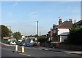
6
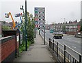
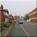
Bobbers Mill Bridge and Alfreton Road
Looking towards the city towards the end of the rush hour on a misty April Tuesday, with plenty of parking spaces in the city-centre multi-storeys. To the left is the parapet of the part of the bridge which crosses the River Leen. A City Transport Turquoise Line No 77 is making for Aspley Lane and Strelley.
Image: © John Sutton
Taken: 29 Apr 2014
0.04 miles
7
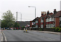
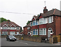
Alfreton Road: approaching Churchfield Lane
The semi-detached houses on the right and those behind them on Newquay Avenue, Lynmouth and Truro Crescents were built in the late 1930s, as was the Capitol Cinema (now a gospel church), whose tower shows over the tiled roofs. The KFC outlet on the corner of Churchfield Lane is a more recent addition; it stands where there were once lock-up garages and advertising hoardings.
Image: © John Sutton
Taken: 29 Apr 2011
0.04 miles
8
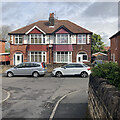
Newquay Avenue: 2023 Coronation decorations
I lived on Newquay Avenue as a child and remember the flags and bunting flying from almost every house on Coronation Day in 1953. Seventy years on times have changed and I saw almost no outward signs of enthusiasm for the event in Nottingham in the days before it. This time the house behind the white car was the only one on Newquay Avenue with flags and pictures of the King.
Image: © John Sutton
Taken: 5 May 2023
0.04 miles
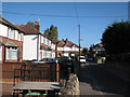
9
A misty morning in Newquay Avenue
A view towards Churchfield Lane and Alfreton Road, with the former Capitol Cinema, now a gospel church, on the right. The air-raid shelter has had a coat of masonry paint since I last passed this way.
Image: © John Sutton
Taken: 18 Sep 2014
0.04 miles
10
Newquay Avenue and Lynmouth Crescent
To see how much (or how little) this scene has changed in the last fifty-odd years, see Image
Image: © John Sutton
Taken: 29 Apr 2011
0.05 miles