IMAGES TAKEN NEAR TO
Larkdale Street, NOTTINGHAM, NG7 4FZ
Introduction
This page details the photographs taken nearby to Larkdale Street, NG7 4FZ by members of the Geograph project.
The Geograph project started in 2005 with the aim of publishing, organising and preserving representative images for every square kilometre of Great Britain, Ireland and the Isle of Man.

There are currently over 7.5m images from over14,400 individuals and you can help contribute to the project by visiting https://www.geograph.org.uk
Image Map
Images are licensed for reuse under creativecommons.org/licenses/by-sa/2.0
Notes
- Clicking on the map will re-center to the selected point.
- The higher the marker number, the further away the image location is from the centre of the postcode.
Image Listing (244 Images Found)
Images are licensed for reuse under creativecommons.org/licenses/by-sa/2.0
Image
Details
Distance
1
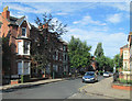
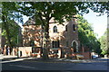
On Burns Street
An August-morning view from the corner of Gedling Grove, looking towards Forest Road West. These streets of substantial houses are part of Nottingham's first suburbs, built to the north of the city's mediaeval core after the Enclosure Act of 1845.
Image: © John Sutton
Taken: 23 Aug 2013
0.02 miles
2
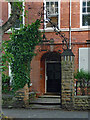
Detail of 111 Forest Road West, Nottingham
Wrought-iron overthrow with lamp (1884, by Sidney Stevenson).
Image: © Stephen Richards
Taken: 19 Jun 2015
0.04 miles
3
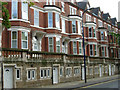
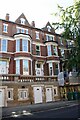
Forest Road West, Nottingham
Substantial villas and leafy streets characterise the Forest Road area between Alfreton Road and Mansfield Road. This was once a prosperous Victorian suburb - a similar district in inner London would no doubt still be considered highly desirable today. Sadly, despite its obvious attractions, this area is run down with most of the houses split into multi-occupancy dwellings and a reputation for high levels of crime. Nevertheless, this row on the south side of Forest Road manages to look impressive.
Image: © Stephen McKay
Taken: 3 Jul 2008
0.04 miles

5
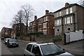
Gedling Grove, Nottingham
Changed very little in the last 29 years!
Image: © David Lally
Taken: 6 Mar 2008
0.05 miles
6
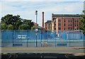
A surviving factory chimney
Most of the chimneys of the former lace factories on Russell, Newdigate and Gamble Streets have been demolished, but there is what Elain Harwood (in the Pevsner Architectural Guide) describes as "a majestic survivor at Albert Mill, a rebuilding by Arthur W Brewill, dated 1893; now flats." For a view of it from Alfreton Road, see Image J H Spray & Co's factory is on the right, behind the modern block.
Image: © John Sutton
Taken: 23 Aug 2013
0.05 miles
7
Houses on the SE side of Forest Road West
There is an Ordnance Survey benchmark Image on the left hand jamb of the road level door of #103
Image: © Luke Shaw
Taken: 14 Sep 2019
0.05 miles
8
Benchmark on left hand jamb on road level door of #103 Forest Road West
Ordnance Survey cut mark benchmark described on the Bench Mark Database at www.bench-marks.org.uk/bm111708
Image: © Luke Shaw
Taken: 14 Sep 2019
0.05 miles
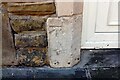
9

Benchmark on wall fronting #58/58a Forest Road West
Ordnance Survey cut mark benchmark levelled at 75.069m above Newlyn Datum in 1986
Image: © Luke Shaw
Taken: 14 Sep 2019
0.06 miles
10
#58a/58 Forest Road West at Southey Street junction
There is an Ordnance Survey benchmark Image on the full height brick wall at its junction with a lower brick wall topped by railings
Image: © Luke Shaw
Taken: 14 Sep 2019
0.06 miles