IMAGES TAKEN NEAR TO
Peveril Street, NOTTINGHAM, NG7 4AJ
Introduction
This page details the photographs taken nearby to Peveril Street, NG7 4AJ by members of the Geograph project.
The Geograph project started in 2005 with the aim of publishing, organising and preserving representative images for every square kilometre of Great Britain, Ireland and the Isle of Man.

There are currently over 7.5m images from over14,400 individuals and you can help contribute to the project by visiting https://www.geograph.org.uk
Image Map
Images are licensed for reuse under creativecommons.org/licenses/by-sa/2.0
Notes
- Clicking on the map will re-center to the selected point.
- The higher the marker number, the further away the image location is from the centre of the postcode.
Image Listing (155 Images Found)
Images are licensed for reuse under creativecommons.org/licenses/by-sa/2.0
Image
Details
Distance
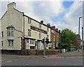
1
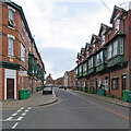
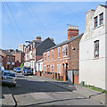
Radford: up Peveril Street
Looking towards Alfreton Road on a cloudy August afternoon. Though Victorian three-storey terraces are common, the wooden first-floor oriel windows are unusual for Nottingham.
Image: © John Sutton
Taken: 25 Aug 2021
0.01 miles
2
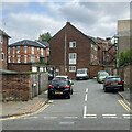
Radford: Aspley Place
Looking from Bentinck Road towards the backs of Victorian and twentieth-century houses on Peveril Street.
Image: © John Sutton
Taken: 25 Aug 2021
0.02 miles
3
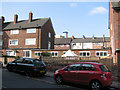
Peveril Street
Of most historical interest is the early 19th-century house with framework-knitter's windows on its third storey (above the red car). These large windows were essential to give the hand-loom weavers enough light. The Alfreton Road frontage of the house is shown in Alan Murray-Rust's photograph of the Alma Inn http://www.geograph.org.uk/photo/1044403. This photograph is also notable in showing the then home, on the left, of the alluring fellow student who shared the Forest Fields Grammar School 0-level English prize with me in 1964.
Image: © John Sutton
Taken: 16 Apr 2010
0.02 miles
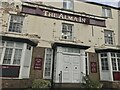
4
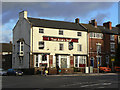
The Alma Inn
The name dates this pub to the period immediately following the Crimean War. Of particular interest however is the adjacent house which retains its top-storey framework knitters windows, the only remaining example in Nottingham.
Image: © Alan Murray-Rust
Taken: 7 Nov 2008
0.03 miles
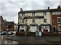
5
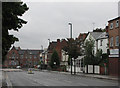
Radford: The Alma and Alfreton Road
A view from the corner of Bentinck Road (left) and Alfreton Road. The early 19th-century house next to the closed pub has third-floor frame-knitter's windows.
Image: © John Sutton
Taken: 25 Aug 2021
0.03 miles
6
The Alma In
With a letter missing, that's not the only thing to make this former pub look to be in a sorry state.
Image: © David Lally
Taken: 8 Feb 2019
0.03 miles
8
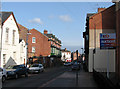
Peveril Street
Looking north towards Bentinck Road and Hyson Green.
Image: © John Sutton
Taken: 16 Apr 2010
0.04 miles
9
Lake Street
A view from the corner of Southey Street, taken on the sunny morning of midsummer day.
Image: © John Sutton
Taken: 21 Jun 2017
0.04 miles
10
Radford: Alfreton Road on a wet morning
Bentinck Road school is on the corner of Bentinck Road. The right-hand side of Alfreton Road is made up of a mixture of Georgian and Victorian buildings. The white building to the right, once The Spread Eagle public house, was a childhood home of the philosopher Herbert Spencer.
Image: © John Sutton
Taken: 26 Aug 2010
0.05 miles