IMAGES TAKEN NEAR TO
Derby Road, NOTTINGHAM, NG7 1LR
Introduction
This page details the photographs taken nearby to Derby Road, NG7 1LR by members of the Geograph project.
The Geograph project started in 2005 with the aim of publishing, organising and preserving representative images for every square kilometre of Great Britain, Ireland and the Isle of Man.

There are currently over 7.5m images from over14,400 individuals and you can help contribute to the project by visiting https://www.geograph.org.uk
Image Map
Images are licensed for reuse under creativecommons.org/licenses/by-sa/2.0
Notes
- Clicking on the map will re-center to the selected point.
- The higher the marker number, the further away the image location is from the centre of the postcode.
Image Listing (413 Images Found)
Images are licensed for reuse under creativecommons.org/licenses/by-sa/2.0
Image
Details
Distance
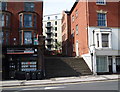
1
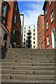
Steps from Derby Road
Just to the west of Canning Circus These steps lead from between a row of shops to the back of a new apartment block in Ilkeston Road.
Image: © David Lally
Taken: 14 Apr 2010
0.01 miles
2
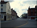
Buildings on Derby Road, Nottingham
By the junction (with Elliott Street) is Alton's Cigar Factory http://list.english-heritage.org.uk/resultsingle.aspx?uid=1247221&searchtype=mapsearch . http://www.bodenassociates.co.uk/city-centre-apartments-and-offices/altons-cigar-factory/ describes its conversion into modern apartments. Further down the road is Image http://list.english-heritage.org.uk/resultsingle.aspx?uid=1247531&searchtype=mapsearch .
Image: © Derek Harper
Taken: 12 Oct 2014
0.01 miles
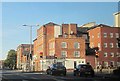
4
Nottingham - NG7 (Canning Circus Area)
An extremely faded inscription on the brickwork of the house on the right - between the two metal brackets securing the drainpipe to the wall - declares this to be "Park Hill". It seems likely that in the path this set of steps, plus a short path or passageway, connected Derby Road (seen at the foot of these steps) with Ilkeston Road. In the distance there is gated access to a modern block of apartments that are currently being used by students. Unfortunately pedestrians are obliged to pass through the rather insalubrious, raised forecourt that exists between the two older houses.
Image: © David Hallam-Jones
Taken: 10 Jun 2012
0.02 miles
5
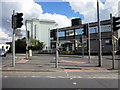
Canning Circus Police Station, Nottingham
Image: © Roy Hughes
Taken: 26 Apr 2013
0.02 miles
6
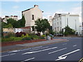
Nottingham - NG7 (Canning Circus area)
A row of white painted properties on Derby Road (A6200) are complemented by a dressed wedding car. Behind the bus stop is the home of the Nottingham First Spiritualist Church and in the distance is Canning Circus Police Station. Addendum (09/04/16) : This police station will have closed by 17/04/16, after which its services will be transferred to the new "Central Police Station" in Byron House, Maid Marion Way, NG1.
Image: © David Hallam-Jones
Taken: 5 May 2012
0.02 miles
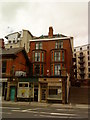
7
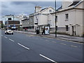
Houses on Derby Road
Early 19th century semi-detached houses just to the west of Canning Circus. The second and third pairs are both Listed Grade II, the latter now being a Spiritualist Church.
Image: © Alan Murray-Rust
Taken: 9 Feb 2014
0.03 miles
8
Nottingham - NG7 (Park)
A house on this plot of land on St Helen's Street (part of the Canning Circus island) was where John Leaver, the inventor of the Leavers lace machine (1815), used to live. The house was demolished in 1959.
Image: © David Hallam-Jones
Taken: 10 Jun 2012
0.03 miles
9
Nottingham - NG7 (Canning Circus)
Ilkeston Road is clearly not a through-road any longer. Although this cul-de-sac at the side of the well-known Sir John Borlase Warren pub 'seems' a calm oasis, in fact it forms the hub of very busy traffic island.
Image: © David Hallam-Jones
Taken: 10 Jun 2012
0.03 miles
10
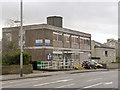
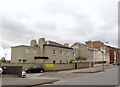
Canning Circus Police Station
A typical piece of functional architecture from around 1960, it has survived the various reorganisations of police forces.
Image: © Alan Murray-Rust
Taken: 9 Feb 2014
0.03 miles