IMAGES TAKEN NEAR TO
Pelham Crescent, NOTTINGHAM, NG7 1AW
Introduction
This page details the photographs taken nearby to Pelham Crescent, NG7 1AW by members of the Geograph project.
The Geograph project started in 2005 with the aim of publishing, organising and preserving representative images for every square kilometre of Great Britain, Ireland and the Isle of Man.

There are currently over 7.5m images from over14,400 individuals and you can help contribute to the project by visiting https://www.geograph.org.uk
Image Map
Images are licensed for reuse under creativecommons.org/licenses/by-sa/2.0
Notes
- Clicking on the map will re-center to the selected point.
- The higher the marker number, the further away the image location is from the centre of the postcode.
Image Listing (176 Images Found)
Images are licensed for reuse under creativecommons.org/licenses/by-sa/2.0
Image
Details
Distance
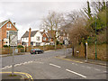
1
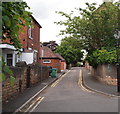
Nottingham - NG7 (Park)
Barrack Lane from the junction with Pelham Crescent looking in the Derby Road direction, i.e. looking out of the estate from one of the estate's outer edges.
Image: © David Hallam-Jones
Taken: 10 Jun 2012
0.01 miles
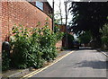
2
Barrack Lane
Showing the location of the boundary marked seen in this photo http://www.geograph.org.uk/photo/3938633
Image: © Alan Murray-Rust
Taken: 16 Apr 2014
0.01 miles
3
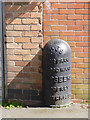
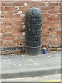
Boundary marker, Barrack Lane
One of a pair of boundary markers on Barrack Lane http://www.geograph.org.uk/photo/3938625 installed to establish boundaries for Poor Rate areas in Nottingham in 1869. This one refers to the Parish of Standard Hill. Listed Grade II.
Image: © Alan Murray-Rust
Taken: 16 Apr 2014
0.02 miles
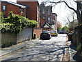
4
Nottingham - NG7 - (Park)
A 'parish road marker' on one of the less smart entrances/exits in and out of the exclusive Park Estate. This is the view looking along Barrack Lane towards Pelham Crescent from the Derby Road end. The metal marker declares this to be part of the Standard Hill parish (wherein also lies Nottingham Castle) and it names the Overseer of roads as a certain Mr C. Woodward and the Assistant Overseer as a Mr T. Geoffrey.
Image: © David Hallam-Jones
Taken: 15 Jun 2012
0.05 miles
5
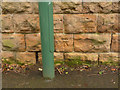
Parish boundary marker, Barrack Lane
Classic Nottingham round headed cast iron boundary post, dated 1869. Listed Grade II.
When I last passed this way in 2014, it was unphotographable under luxuriant buddleia, much as this view http://www.geograph.org.uk/photo/2993882 , but worse.
Image: © Alan Murray-Rust
Taken: 12 Jun 2018
0.05 miles
6
Bench mark, Harlaxton Drive
See http://www.geograph.org.uk/photo/3845558 for location.
Image: © Alan Murray-Rust
Taken: 9 Feb 2014
0.05 miles
8
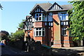
2 Harlaxton Drive, Nottingham
An Edwardian house.
Image: © Andrew Abbott
Taken: 25 May 2020
0.06 miles
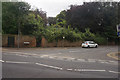
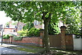
9
Harlaxton Drive, off Derby Road
The retaining and garden walls in local sandstone are typical of this area. There is a bench mark http://www.geograph.org.uk/photo/3845556 just to the right of the lighting column.
Image: © Alan Murray-Rust
Taken: 9 Feb 2014
0.06 miles
10
Wall fronting #7 Cavendish Crescent North, 'Jardine House'
Image: © Roger Templeman
Taken: 15 Aug 2015
0.06 miles