IMAGES TAKEN NEAR TO
Sunningdale Road, NOTTINGHAM, NG6 9LW
Introduction
This page details the photographs taken nearby to Sunningdale Road, NG6 9LW by members of the Geograph project.
The Geograph project started in 2005 with the aim of publishing, organising and preserving representative images for every square kilometre of Great Britain, Ireland and the Isle of Man.

There are currently over 7.5m images from over14,400 individuals and you can help contribute to the project by visiting https://www.geograph.org.uk
Image Map (Loading...)


Getting Data...Please wait
Leaflet Map data © OpenStreetMap
Images are licensed for reuse under creativecommons.org/licenses/by-sa/2.0
Notes
- Clicking on the map will re-center to the selected point.
- The higher the marker number, the further away the image location is from the centre of the postcode.
Image Listing (15 Images Found)
Images are licensed for reuse under creativecommons.org/licenses/by-sa/2.0
Image
Details
Distance
1
Bulwell NG5, Notts.
A footpath along the western boundary of Potter's Hollow Recreation Ground. To the photographer's right lies Hucknall Road, the A611 road, linking Nottingham and Hucknall. The Great Central Railway line once ran along this western edge. It was the last main line built to London, opening to passenger traffic in 1900. It seems that trains from Manchester and Sheffield passed alongside Bulwell Common and through Bulwell Common Station on their way to Marylebone.
Image: © David Hallam-Jones
Taken: 17 May 2013
0.07 miles
2

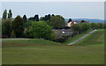
Bulwell Common
The trees and houses to the left of the common are on the site of Bulwell Common Station and its associated goods and carriage sidings, built by the Great Central Railway in 1898. The station closed to passengers in 1963 and to all traffic in 1968. It is now hard to imagine there was ever a main line running north through Bulwell.
Image: © John Sutton
Taken: 6 May 2011
0.08 miles
3

Bestwood NG5, Notts.
A view of Gala Way on the opposite side of Hucknall Road (the A611) is seen here from the eastern edge of Potter's Hollow Recreation Ground. The stones are two of a linear series of similar stones that have been installed in the gaps in the tree-line of a copse that runs parallel with Hucknall Road. It seems likely that the object of the stones is to prevent 'travellers' setting up an illegal camp. Gala Road is a cul-de-sac serving a 'light industrial' zone.
Image: © David Hallam-Jones
Taken: 17 May 2013
0.09 miles
4

Bulwell NG5, Notts.
The commencement (or conclusion) of a footpath off Hucknall Road (the A611). The fence in the distance runs almost parallel with St Albans Road, Bulwell. The stones are two in a linear series of similar stones that have been installed in the gaps in the tree-line of a copse that runs parallel with Hucknall Road. It seems likely that the object of the stones is to prevent 'travellers' setting up camp here in what is known as Potter's Hollow Recreation Ground.
Image: © David Hallam-Jones
Taken: 17 May 2013
0.10 miles
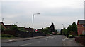
5
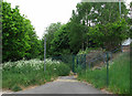
Former course of the Leen Valley Railway
The line of trees straight ahead marks the course of the Great Northern Railway's Leen Valley line, built in 1881 to serve collieries north of Nottingham and closed to passengers in 1929 and to all traffic in 1968. It is now a footpath beside Hucknall Road, on the eastern side of Bulwell Common.
Image: © John Sutton
Taken: 6 May 2011
0.13 miles
6
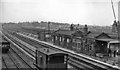
Bulwell Common Station
View southwards, towards Nottingham (Victoria); ex-Great Central 'London Extension' main line, (Annesley) - Nottingham - Leicester (Central) - Marylebone, closed (down to Quainton Road and Aylesbury) 5/9/66. This station was closed on 4/3/63, just four months before the photograph. (There is no trace of the railway there 45 years later).
Image: © Ben Brooksbank
Taken: 12 Jul 1963
0.13 miles
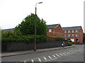
7
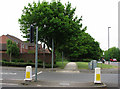
Rigley Drive
Rigley Drive - seen here at the junction with Hucknall Road - takes its name from William Rigley's railway wagon works, which stood to the left of here until the 1960s, specialising in the manufacture and repair of railway wagons and, latterly, the scrapping of steam locomotives. The Great Northern Railway's Leen Valley line, built in 1881 to serve collieries in the Leen valley, ran directly ahead and behind the camera until closure in 1968. Bulwell Forest Station (also behind the camera) closed to passengers as early as 1929.
Image: © John Sutton
Taken: 6 May 2011
0.17 miles
8
Kersall Drive: former railway bridge
The substantial blue-brick walls either side of Kersall Drive were, until 1968, the parapets of a bridge which crossed the Great Central Railway Nottingham-Sheffield main line. Bulwell Common South Junction was just to the right and Bulwell Common Station a little further north; to the left the main line ran south through New Basford to Nottingham Victoria and a line diverged to the west to Basford North (formerly Basford & Bulwell) Station. This bridge was wide as it crossed a number of tracks. Since closure the railway land has been redeveloped as housing. See Image] and Image] for other angles.
Image: © John Sutton
Taken: 6 May 2011
0.18 miles
9

Railway bridge parapet, Kersall Drive
The houses on the other side of this blue-brick wall are built on a filled-in cutting of what was once the Great Central Railway main line from Marylebone to Sheffield, via Leicester Central and Nottingham Victoria. This was the last main line to be built (1898) and the first to close (1966 as a through route and 1968 here to goods traffic). See Image] and Image] for other angles.
Image: © John Sutton
Taken: 6 May 2011
0.18 miles
10
Vestiges of the Great Central Railway
The blue-brick wall was once the parapet of a bridge which carried Kersall Drive over a number of tracks immediately south of Bulwell Common South Junction. The Great Central Railway main line from Marylebone to Sheffield, via Leicester Central and Nottingham Victoria was the last main line to be built (1898) and the first to close (1966 as a through route and 1968 here to goods traffic). Since closure the railway land has been redeveloped as housing. See Image] and Image] for other angles.
Image: © John Sutton
Taken: 6 May 2011
0.18 miles