IMAGES TAKEN NEAR TO
Westhouse Road, NOTTINGHAM, NG6 8ZQ
Introduction
This page details the photographs taken nearby to Westhouse Road, NG6 8ZQ by members of the Geograph project.
The Geograph project started in 2005 with the aim of publishing, organising and preserving representative images for every square kilometre of Great Britain, Ireland and the Isle of Man.

There are currently over 7.5m images from over14,400 individuals and you can help contribute to the project by visiting https://www.geograph.org.uk
Image Map
Images are licensed for reuse under creativecommons.org/licenses/by-sa/2.0
Notes
- Clicking on the map will re-center to the selected point.
- The higher the marker number, the further away the image location is from the centre of the postcode.
Image Listing (24 Images Found)
Images are licensed for reuse under creativecommons.org/licenses/by-sa/2.0
Image
Details
Distance
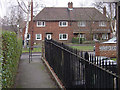
1
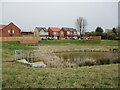
New housing and balancing pond, Bestwood Village
Image: © Jonathan Thacker
Taken: 31 Mar 2022
0.04 miles
2
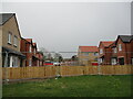
Houses under construction, Bestwood Village
Image: © Jonathan Thacker
Taken: 31 Mar 2022
0.06 miles
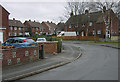
3
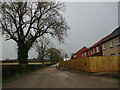
Roadway and public footpath on the edge of Bestwood Village
New housing under construction on the right.
Image: © Jonathan Thacker
Taken: 31 Mar 2022
0.07 miles
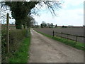
6
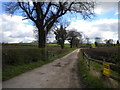
Track to Westhouse Farm
Off Moor Road north of Bestwood Village; also hosting a public footpath. The yellow sign (right) warns walkers that their movements will be recorded on CCTV or similar.
Image: © Richard Vince
Taken: 2 Apr 2017
0.08 miles
7
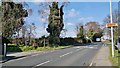
Moor Road at Bestwood
Heading out of the village.
Image: © Chris Morgan
Taken: 10 Mar 2014
0.09 miles
9
Bestwood Village, The Spinney
The Robin Hood Way emerges into this quiet cul-de-sac
Image: © Alan Murray-Rust
Taken: 13 Jan 2008
0.10 miles
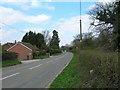
10
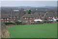
Bestwood Village, The Spinney
This is the most northern extension to the village and probably dates from the 1960s. This is the view looking west towards Hucknall.
Image: © Alan Murray-Rust
Taken: 13 Jan 2008
0.11 miles