IMAGES TAKEN NEAR TO
Blenheim Park Road, NOTTINGHAM, NG6 8YP
Introduction
This page details the photographs taken nearby to Blenheim Park Road, NG6 8YP by members of the Geograph project.
The Geograph project started in 2005 with the aim of publishing, organising and preserving representative images for every square kilometre of Great Britain, Ireland and the Isle of Man.

There are currently over 7.5m images from over14,400 individuals and you can help contribute to the project by visiting https://www.geograph.org.uk
Image Map
Images are licensed for reuse under creativecommons.org/licenses/by-sa/2.0
Notes
- Clicking on the map will re-center to the selected point.
- The higher the marker number, the further away the image location is from the centre of the postcode.
Image Listing (8 Images Found)
Images are licensed for reuse under creativecommons.org/licenses/by-sa/2.0
Image
Details
Distance
1
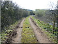
Cart Track
Track round fishing pond, Image, leading to a stable. Blenhiem Industrial Estate can be seen in the back-ground.
Image: © Tony Bacon
Taken: 4 Apr 2007
0.02 miles
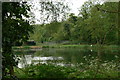
2
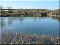
Fishing Pond
Picturesque pond just yards from the vast, developing Blenhiem Industrial Estate, the roofs of which can be seen in the top left background.
Image: © Tony Bacon
Taken: 4 Apr 2007
0.06 miles
3
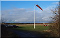
Nottingham, NG15 - Blenheim Lane
Having left Bullwell-Woodhall Farm (sic) behind, this is a view seen by walkers as they proceed in the direction of Camberley Road (the A6002) and pass by the control tower and windsock features of the private flying club that is based on this southerly edge of Hucknall Aerodrome. A little way ahead is the boundary separating the Ashfield and Nottingham Council administrative areas. The Robin Hood Way/Trail between Nottingham and Edwinstowe also uses this stretch of Blenheim Lane.
Image: © David Hallam-Jones
Taken: 15 Dec 2012
0.16 miles
4
Nottingham, NG15 - Westville, Hucknall
Halfway along Blenheim Lane - a "No Through Road" - that is off Camberley Road (the A6002) there is a gated emergency entrance/exit in and out of Hucknall Aerodrome, the base of a private flying club and a Rolls Royce components manufacturing site with its main entrance on Watnall Road (the B6009), on the opposite side of the aerodrome. Approximately one third of the way up Blenheim Lane towards Bullwell-Woodhall Farm (sic), i.e behind the photographer, is the boundary separating the Ashfield and Nottingham Council administrative areas. The Robin Hood Way/Trail) between Nottingham and Edwinstowe also uses this stretch of Blenheim Lane.
Image: © David Hallam-Jones
Taken: 15 Dec 2012
0.20 miles
5

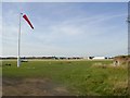
Blenheim Lane and windsock
This is an emergency exit from Watnall Airfield. Blenheim Lane continues on to Bulwellwood Hall Farm.
Image: © Alan Murray-Rust
Taken: 27 Aug 2009
0.21 miles
6
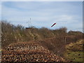
Hucknall Aerodrome
Where the most famous of the Rolls Royce engines were tested. On a Sunday afternoon all activity was from private planes however the name of Rolls Royce was still painted on the large hangar in the distance. Notice the WW2 pill box on the right.
Image: © Mick Garratt
Taken: 21 Aug 2005
0.22 miles
7
Pond at Bulwell Wood
Now used as a private fishery.
Image: © Alan Murray-Rust
Taken: 21 May 2010
0.22 miles
8
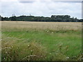
Hucknall Airfield
This is a view across the scrubland at the edge of the airfield towards the chimneys in square SK5047.
Image: © Oxymoron
Taken: 11 Aug 2008
0.23 miles