IMAGES TAKEN NEAR TO
Firth Way, NOTTINGHAM, NG6 8XF
Introduction
This page details the photographs taken nearby to Firth Way, NG6 8XF by members of the Geograph project.
The Geograph project started in 2005 with the aim of publishing, organising and preserving representative images for every square kilometre of Great Britain, Ireland and the Isle of Man.

There are currently over 7.5m images from over14,400 individuals and you can help contribute to the project by visiting https://www.geograph.org.uk
Image Map
Images are licensed for reuse under creativecommons.org/licenses/by-sa/2.0
Notes
- Clicking on the map will re-center to the selected point.
- The higher the marker number, the further away the image location is from the centre of the postcode.
Image Listing (24 Images Found)
Images are licensed for reuse under creativecommons.org/licenses/by-sa/2.0
Image
Details
Distance
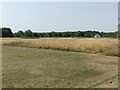
1
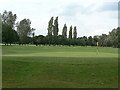
Nottingham City Golf Club
Created on the site of the estate of Bulwell Hall
Image: © Alan Murray-Rust
Taken: 27 Aug 2009
0.07 miles
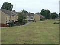
2
The back of Bacton Avenue
The well mown grass adjacent to the houses contrasts with the unkempt grassland to the right.
Image: © Alan Murray-Rust
Taken: 19 Jul 2022
0.11 miles
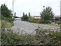
3

Camberley Road
Part of the Nottingham western orbital corridor developed in the 1980s.
Image: © Alan Murray-Rust
Taken: 27 Aug 2009
0.12 miles
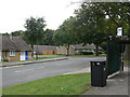
4
Acle Gardens
1960s council development in Bulwell. The hedge to the right hides the houses from the busy A6002, Camberley Road.
Image: © Alan Murray-Rust
Taken: 27 Aug 2009
0.15 miles
5
Hemsby Gardens
Part of the large areas of council residential development to the west of Bulwell in the 1960s to 1980s.
Image: © Alan Murray-Rust
Taken: 27 Aug 2009
0.15 miles
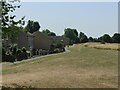
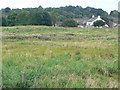
6
Open space between Hoewood Road and Camberley Road
Mapped as 'Playing Field' it is now effectively scrub grassland with bramble thickets and a few informal pathways through it.
Image: © Alan Murray-Rust
Taken: 19 Jul 2022
0.15 miles
7
Open space
Shown on OS maps as Recreation Ground or Playing Field, but now rather overgrown. The Coopers Arms Image can be seen beyond.
Image: © Alan Murray-Rust
Taken: 27 Aug 2009
0.18 miles
8
Firth Way
Industrial Estate on what was formerly quarries from which the distinctive local Bulwell sandstone came.
Image: © Alan Murray-Rust
Taken: 27 Aug 2009
0.18 miles
9
Norwich Gardens
A development of elderly persons' bungalows right on the edge of the built up area, and almost cut off by the development of Camberley Road as part of the Nottingham western orbital corridor.
Image: © Alan Murray-Rust
Taken: 27 Aug 2009
0.20 miles
10
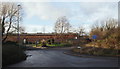
Nottingham, NG6 - Bulwell
Blenheim Lane, lying directly ahead, and Firth Way on the right, are both off Camberley Road (i.e. the A6002). At the closed end of Blenheim Lane (a "No Through Road") is Bulwell-Woodhall Farm (sic). In addition, halfway along it is a gated emergency entrance/exit in and out of Hucknall Aerodrome, the base of a private flying club and a Rolls Royce components manufacturing site that has its main entrance on Watnall Road (the B6009) on the northerly side of the aerodrome. The brown building/s ahead are part of Blenheim Industrial Estate.
Image: © David Hallam-Jones
Taken: 15 Dec 2012
0.20 miles