IMAGES TAKEN NEAR TO
Aldgate Close, NOTTINGHAM, NG6 8UQ
Introduction
This page details the photographs taken nearby to Aldgate Close, NG6 8UQ by members of the Geograph project.
The Geograph project started in 2005 with the aim of publishing, organising and preserving representative images for every square kilometre of Great Britain, Ireland and the Isle of Man.

There are currently over 7.5m images from over14,400 individuals and you can help contribute to the project by visiting https://www.geograph.org.uk
Image Map (Loading...)


Getting Data...Please wait
Leaflet Map data © OpenStreetMap
Images are licensed for reuse under creativecommons.org/licenses/by-sa/2.0
Notes
- Clicking on the map will re-center to the selected point.
- The higher the marker number, the further away the image location is from the centre of the postcode.
Image Listing (12 Images Found)
Images are licensed for reuse under creativecommons.org/licenses/by-sa/2.0
Image
Details
Distance
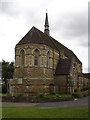
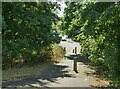
2
Nottingham, NG6 - Bulwell
Halfway along Rufford Walk - a pedestrian walkway that links the Blenheim area of Bulwell with the 'non town centre end' of Commercial Road - an Anglican Church known as St John the Divine - can be found occupying this grass covered plot surrounded by a council housing estate. Behind the blue-painted fences ahead are the two separate Rufford Junior & Infant Schools.
Image: © David Hallam-Jones
Taken: 15 Dec 2012
0.07 miles
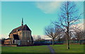
3
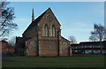
Nottingham, NG6 - Bulwell
Halfway along Rufford Walk - a pedestrian walkway that links the Blenheim area of Bulwell with the 'non town centre end' of Commercial Road - St John's Anglican Church can be found occupying this grassy area, surrounded by a council housing estate. The houses on the right are on Keys Close whilst the two separate Rufford Junior & Infant Schools are situated immediately on the left, albeit off this picture.
Image: © David Hallam-Jones
Taken: 15 Dec 2012
0.07 miles
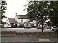
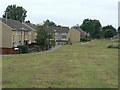
5
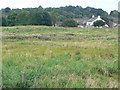
Open space
Shown on OS maps as Recreation Ground or Playing Field, but now rather overgrown. The Coopers Arms Image can be seen beyond.
Image: © Alan Murray-Rust
Taken: 27 Aug 2009
0.14 miles
6
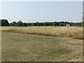
Open space between Hoewood Road and Camberley Road
Mapped as 'Playing Field' it is now effectively scrub grassland with bramble thickets and a few informal pathways through it.
Image: © Alan Murray-Rust
Taken: 19 Jul 2022
0.17 miles
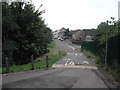
7
Cycle ways in Bulwell
Recreating this 'First' for the square https://www.geograph.org.uk/photo/49365
Image: © Alan Murray-Rust
Taken: 19 Jul 2022
0.19 miles
8
Cycle ways in Bulwell
from Camberley Road leading down to Bardney Drive
Image: © Tom Courtney
Taken: 5 Sep 2005
0.19 miles
9

Camberley Road
Part of the Nottingham western orbital corridor developed in the 1980s.
Image: © Alan Murray-Rust
Taken: 27 Aug 2009
0.21 miles
10
Hemsby Gardens
Part of the large areas of council residential development to the west of Bulwell in the 1960s to 1980s.
Image: © Alan Murray-Rust
Taken: 27 Aug 2009
0.22 miles