IMAGES TAKEN NEAR TO
Gaul Street, NOTTINGHAM, NG6 8HY
Introduction
This page details the photographs taken nearby to Gaul Street, NG6 8HY by members of the Geograph project.
The Geograph project started in 2005 with the aim of publishing, organising and preserving representative images for every square kilometre of Great Britain, Ireland and the Isle of Man.

There are currently over 7.5m images from over14,400 individuals and you can help contribute to the project by visiting https://www.geograph.org.uk
Image Map (Loading...)


Getting Data...Please wait
Leaflet Map data © OpenStreetMap
Images are licensed for reuse under creativecommons.org/licenses/by-sa/2.0
Notes
- Clicking on the map will re-center to the selected point.
- The higher the marker number, the further away the image location is from the centre of the postcode.
Image Listing (36 Images Found)
Images are licensed for reuse under creativecommons.org/licenses/by-sa/2.0
Image
Details
Distance
1
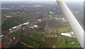
Bulwell: aerial 2014
Barker's Wood bottom centre, with Camberley Road running left-right above it.
Image: © Chris
Taken: 9 Apr 2014
0.04 miles
2
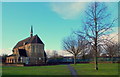
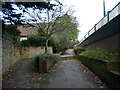
Nottingham, NG6 - Bulwell
Halfway along Rufford Walk - a pedestrian walkway that links the Blenheim area of Bulwell with the 'non town centre end' of Commercial Road - an Anglican Church known as St John the Divine - can be found occupying this grass covered plot surrounded by a council housing estate. Behind the blue-painted fences ahead are the two separate Rufford Junior & Infant Schools.
Image: © David Hallam-Jones
Taken: 15 Dec 2012
0.13 miles
4
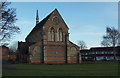
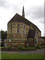
Nottingham, NG6 - Bulwell
Halfway along Rufford Walk - a pedestrian walkway that links the Blenheim area of Bulwell with the 'non town centre end' of Commercial Road - St John's Anglican Church can be found occupying this grassy area, surrounded by a council housing estate. The houses on the right are on Keys Close whilst the two separate Rufford Junior & Infant Schools are situated immediately on the left, albeit off this picture.
Image: © David Hallam-Jones
Taken: 15 Dec 2012
0.16 miles
5
Nottingham, NG6 - Bulwell
Commercial Road peters out here immediately to the right and continues as a pedestrian underpass under an ugly flyover segment of Main Street. However, despite its rather sad surroundings, Strelley House in its overgrown garden remains to fascinate passers-by at the side of what was previously known as Quarry Road. This late 19th century building with its shaped gables, quoins and dentilled string courses was built for George Strelley, late of Hemshill, Nottinghamshire, "for educating and teaching the young children of the parish". When this 'free school' was discontinued in December 1885 the building was sold and the proceeds were set aside for scholarships that were awarded from the George Strelley Endowment Fund. The coat of arms above the porch bears the date 1667, something that reflects the family history as opposed to the building's construction date. It now appears to be a privately owned residence.The houses beyond it are on Muriel Street, on the opposite side of Strelly (sic) Street.
Image: © David Hallam-Jones
Taken: 15 Dec 2012
0.17 miles
7
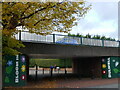
Bulwell High Road crossing Commercial Road
Image: © Jonathan Thacker
Taken: 3 Nov 2023
0.18 miles
8
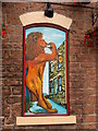
The Lion Revived !
Wall mural on bricked-up window of the public house of the same name
Image: © Chris Eaton
Taken: 11 Jul 2007
0.18 miles
10
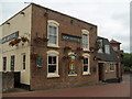
The Lion Revived in Bulwell
Unusual for a public house - traditional stone facings on the frontage, and a flat roof - and the beer is good too !
Image: © Chris Eaton
Taken: 11 Jul 2007
0.19 miles