Nottingham, NG6 - Bulwell
Introduction
The photograph on this page of Nottingham, NG6 - Bulwell by David Hallam-Jones as part of the Geograph project.
The Geograph project started in 2005 with the aim of publishing, organising and preserving representative images for every square kilometre of Great Britain, Ireland and the Isle of Man.

There are currently over 7.5m images from over 14,400 individuals and you can help contribute to the project by visiting https://www.geograph.org.uk
Nottingham, NG6 - Bulwell
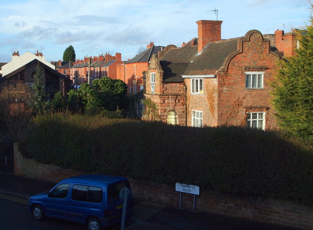
Image: © David Hallam-Jones Taken: 15 Dec 2012
Commercial Road peters out here immediately to the right and continues as a pedestrian underpass under an ugly flyover segment of Main Street. However, despite its rather sad surroundings, Strelley House in its overgrown garden remains to fascinate passers-by at the side of what was previously known as Quarry Road. This late 19th century building with its shaped gables, quoins and dentilled string courses was built for George Strelley, late of Hemshill, Nottinghamshire, "for educating and teaching the young children of the parish". When this 'free school' was discontinued in December 1885 the building was sold and the proceeds were set aside for scholarships that were awarded from the George Strelley Endowment Fund. The coat of arms above the porch bears the date 1667, something that reflects the family history as opposed to the building's construction date. It now appears to be a privately owned residence.The houses beyond it are on Muriel Street, on the opposite side of Strelly (sic) Street.
Images are licensed for reuse under creativecommons.org/licenses/by-sa/2.0
Image Location
Latitude
53.001954
Longitude
-1.198126