IMAGES TAKEN NEAR TO
NOTTINGHAM, NG6 8GJ
Introduction
This page details the photographs taken nearby to NG6 8GJ by members of the Geograph project.
The Geograph project started in 2005 with the aim of publishing, organising and preserving representative images for every square kilometre of Great Britain, Ireland and the Isle of Man.

There are currently over 7.5m images from over14,400 individuals and you can help contribute to the project by visiting https://www.geograph.org.uk
Image Map (Loading...)


Getting Data...Please wait
Leaflet Map data © OpenStreetMap
Images are licensed for reuse under creativecommons.org/licenses/by-sa/2.0
Notes
- Clicking on the map will re-center to the selected point.
- The higher the marker number, the further away the image location is from the centre of the postcode.
Image Listing (26 Images Found)
Images are licensed for reuse under creativecommons.org/licenses/by-sa/2.0
Image
Details
Distance
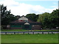
2
Squires Avenue, Bulwell
At this point, Squires Avenue becomes a side road to Hucknall Lane, with the main road into Bulwell town centre continuing as Ravensworth Road (right). Part of Bulwell Academy (the former River Leen School site) is visible through the fence on the left.
Image: © Richard Vince
Taken: 15 Sep 2012
0.07 miles
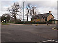
3
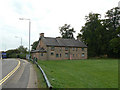
Bulwell Hall Park, Bulwell NG6, Notts.
A glimpse of the A6002 as it passes in front of "Chris Firth's Cottages", seen here occupying a corner of Bulwell Hall Park. They were formerly known as "Stone Cottages" and were built (date?) to house estate workers. The building may still be housing a municipal toy library?
Image: © David Hallam-Jones
Taken: 22 Feb 2014
0.10 miles
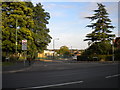
4
Bulwell NG6, Notts.
The A6002 from the east (on the left) heading westwards towards the main junction with Hucknall Road. This is the view from Squires Avenue. "Chris Firth's Cottages", seen here occupying a corner of Bulwell Hall Park, were formerly known as "Stone Cottages". They were built (date?) to house estate workers and may still be housing a municipal toy library?
Image: © David Hallam-Jones
Taken: 22 Feb 2014
0.10 miles
5
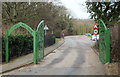
Bulwell Hall Park, Bulwell NG6, Notts.
The ornate metallic entrance gates off Norwich Gardens, a cul-de-sac.
Image: © David Hallam-Jones
Taken: 22 Feb 2014
0.11 miles
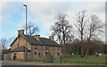
6
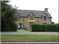
Bulwell Community Toy Library
Housed in a group of cottages built in the local stone.
Image: © Alan Murray-Rust
Taken: 27 Aug 2009
0.11 miles
7
Chris Firth Cottages
Originally estate cottages on the Bulwell Hall Estate, they now house a community toy library Image
Image: © Alan Murray-Rust
Taken: 27 Aug 2009
0.12 miles
8
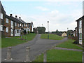
Riseborough Walk and Wingbourne Walk
Built in the style favoured in the 1960s and 70s with the front of the houses facing onto landscaped pedestrian access areas, with vehicle access at the rear.
Image: © Alan Murray-Rust
Taken: 27 Aug 2009
0.12 miles
9
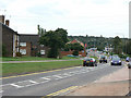
Sandhurst Road
Developed fundamentally as a relatively quiet residential road, in the 1980s it became part of the Nottingham western orbital road, with levels of traffic to match.
Image: © Alan Murray-Rust
Taken: 27 Aug 2009
0.12 miles
10
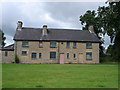
Bulwell Community Toy Library
View of the rear of the building taken from the playing fields.
Image: © Oxymoron
Taken: 10 Jul 2008
0.12 miles