IMAGES TAKEN NEAR TO
Bestwood Park, NOTTINGHAM, NG5 8NF
Introduction
This page details the photographs taken nearby to Bestwood Park, NG5 8NF by members of the Geograph project.
The Geograph project started in 2005 with the aim of publishing, organising and preserving representative images for every square kilometre of Great Britain, Ireland and the Isle of Man.

There are currently over 7.5m images from over14,400 individuals and you can help contribute to the project by visiting https://www.geograph.org.uk
Image Map
Images are licensed for reuse under creativecommons.org/licenses/by-sa/2.0
Notes
- Clicking on the map will re-center to the selected point.
- The higher the marker number, the further away the image location is from the centre of the postcode.
Image Listing (49 Images Found)
Images are licensed for reuse under creativecommons.org/licenses/by-sa/2.0
Image
Details
Distance
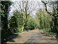
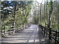
1
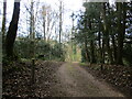
Track to Gaunt's Hill, Bestwood Country Park
Image: © Jonathan Thacker
Taken: 31 Mar 2022
0.05 miles
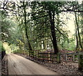
2
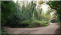
Bestwood Country Park, NG5, Notts.
Gaunt's Hill, off Main Drive has been the subject of a puzzle recently (Sept 2014) about who owns it and who, therefore, is responsible for its upkeep. A single private dwelling lies along it. Bestwood Lodge - now a hotel - is situated 10 minutes walk ahead and the Alexander Lodges, a pair of Gothic Revival style lodges, lie 15-20 minutes walk away behind the photographer.
Image: © David Hallam-Jones
Taken: 21 Nov 2014
0.06 miles
3
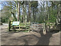
Entrance to Big Wood, Bestwood Country Park
Image: © Jonathan Thacker
Taken: 31 Mar 2022
0.07 miles
4
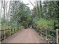
Track to Woodsde Lodge, Bestwood Country Park
Image: © Jonathan Thacker
Taken: 31 Mar 2022
0.07 miles
5
Track at Gaunt's Hill, Bestwood Country Park
Image: © Jonathan Thacker
Taken: 31 Mar 2022
0.08 miles
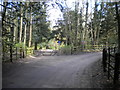
6
Bestwood Country Park, NG6, Notts
Main Drive in the Gaunt's Hill and Bestwood Lodge direction, with an access point for forestry vehicles on the right.
Image: © David Hallam-Jones
Taken: 21 Nov 2014
0.09 miles
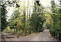
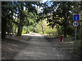
7
Track junction north of Gaunt's Hill, Bestwood Country Park
At this point, the track to the right becomes a public footpath, but is open to vehicles for access to a riding school a quarter of a mile further on. The track ahead forms one of the main paths through the country park, hence the provision of access for pedestrians and horses but not for unauthorised cars.
Image: © Richard Vince
Taken: 2 Apr 2017
0.10 miles
8
Bestwood Country Park, NG6, Notts
Access to the northern section of Main Drive - beyond the low-slung motor vehicle barrier - is evidently restricted. The road on the right however, carries traffic to the Woodside Riding Stables. Beyond the stables the road (that by this point has become a track) leading to Lamin's Lane, is also part of the Bestwood village - Papplewick village section of the Robin Hood Way.
Image: © David Hallam-Jones
Taken: 21 Nov 2014
0.10 miles
9
Track through Bestwood Country Park (2)
A public footpath that also provides vehicular access to a riding school a few hundred yards further on.
Image: © Richard Vince
Taken: 2 Apr 2017
0.10 miles
10
Track through Bestwood Country Park (1)
Open to pedestrians and horses, and also providing vehicular access to Alexandra Lodges about a quarter of a mile further along, hence the speed limit and dead end road signs (the former sign is presumably unofficial as it is in the wrong font).
Image: © Richard Vince
Taken: 2 Apr 2017
0.11 miles