IMAGES TAKEN NEAR TO
Glen Parva Avenue, NOTTINGHAM, NG5 8LZ
Introduction
This page details the photographs taken nearby to Glen Parva Avenue, NG5 8LZ by members of the Geograph project.
The Geograph project started in 2005 with the aim of publishing, organising and preserving representative images for every square kilometre of Great Britain, Ireland and the Isle of Man.

There are currently over 7.5m images from over14,400 individuals and you can help contribute to the project by visiting https://www.geograph.org.uk
Image Map (Loading...)


Getting Data...Please wait
Leaflet Map data © OpenStreetMap
Images are licensed for reuse under creativecommons.org/licenses/by-sa/2.0
Notes
- Clicking on the map will re-center to the selected point.
- The higher the marker number, the further away the image location is from the centre of the postcode.
Image Listing (28 Images Found)
Images are licensed for reuse under creativecommons.org/licenses/by-sa/2.0
Image
Details
Distance
1
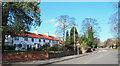
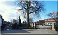
Redhill, NG5, Notts.
Some C19th(?) cottages opposite Monsell Drive on the A60, the main Nottingham to Mansfield road. This is the stretch of the road 2-3 minutes walk north of Redhill Cemetery looking towards the Ram Inn (a local landmark), in the Mansfield direction.
Image: © David Hallam-Jones
Taken: 7 Mar 2014
0.09 miles
2
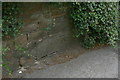
Bench mark, Mansfield Road
A piece of hard stone has been specifically built into the wall for this bench mark as the local sandstone of which the rest of the wall is constructed is soft and weathers easily.
Image: © Alan Murray-Rust
Taken: 20 Jul 2010
0.10 miles
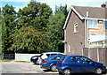
4
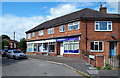
Arnold, Nottingham NG5
A parade of shops with residential accommodation on Stanhope Crescent which is off Cross Street, Arnold. Since early/mid 2023 these premises no longer host the free glossy "NG" magazine business and a white goods retail outlet and as of November 2023 they remain empty. Cross Street, a busy road linking Mansfield Road (the A60) and the centre of Arnold, lies a stone's throw away, behind the photographer.
Image: © David Hallam-Jones
Taken: 23 Aug 2014
0.12 miles
5
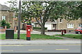
Mansfield Road postbox ref: NG5 415
Standard EIIR pillar box. The name is not particularly helpful as Mansfield Road is several miles long and has a number of postboxes.
Image: © Alan Murray-Rust
Taken: 20 Jul 2010
0.12 miles
6
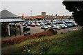
Sainsbury's
With the Home Brewery tower in the distance.
Image: © Mick Garratt
Taken: 5 Jan 2007
0.13 miles
7
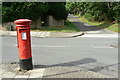
Redhill Lodge Drive postbox ref: NG5 474
Standard EIIR pillar box, distinctly out of vertical.
Image: © Alan Murray-Rust
Taken: 20 Jul 2010
0.13 miles
8
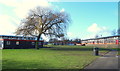
Redhill, NG5, Notts.
A classroom block at Redhill Academy, formerly Redhill Comprehensive School, and part of Arnold Leisure Centre on the left are seen here from Cherry Close.
Image: © David Hallam-Jones
Taken: 16 Feb 2014
0.14 miles
9
Redhill, NG5, Notts.
Redhill Road turns to the left here in front of the entrance into Cherry Close (an unadopted cul-de-sac). Redhill Academy, formerly Redhill Comprehensive School, is seen on the right.
Image: © David Hallam-Jones
Taken: 16 Feb 2014
0.16 miles
10
Redhill, Nottingham NG5
This short snicket at the western-most end of Galway Road joins the main Mansfield-Nottingham road (i.e. the A60) opposite Arnold cemetery.
Image: © David Hallam-Jones
Taken: 23 Aug 2014
0.19 miles