IMAGES TAKEN NEAR TO
Nottingham Road, NOTTINGHAM, NG5 6JZ
Introduction
This page details the photographs taken nearby to Nottingham Road, NG5 6JZ by members of the Geograph project.
The Geograph project started in 2005 with the aim of publishing, organising and preserving representative images for every square kilometre of Great Britain, Ireland and the Isle of Man.

There are currently over 7.5m images from over14,400 individuals and you can help contribute to the project by visiting https://www.geograph.org.uk
Image Map
Images are licensed for reuse under creativecommons.org/licenses/by-sa/2.0
Notes
- Clicking on the map will re-center to the selected point.
- The higher the marker number, the further away the image location is from the centre of the postcode.
Image Listing (82 Images Found)
Images are licensed for reuse under creativecommons.org/licenses/by-sa/2.0
Image
Details
Distance
1
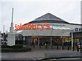
Sainsbury's Arnold
Pedestrian entrance on Nottingham Road.
Image: © M J Richardson
Taken: 2 Jan 2016
0.03 miles

3
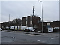
BT at Daybrook
Depot on Nottingham Road.
Image: © M J Richardson
Taken: 2 Jan 2016
0.04 miles
4
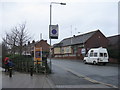
Church Drive East Daybrook
By the entrance to Sainsbury's Arnold, and with the Arnold District Victory Club on the right.
Image: © M J Richardson
Taken: 2 Jan 2016
0.05 miles
5
Charles Street, Arnold, Notts.
Facing Charles Street's junction with Nottingham Road. Nottingham Road is the one of the principal routes into Arnold's commercial heart. "The Old People's Welfare Centre" on the right was built in 1955 as a result of public generosity. It was provided "for the welfare of aged persons in Arnold and Daybrook and District, in perpetuity." It is also available for hire by community groups, e.g. a local amateur dramatic group uses it regularly to stage their productions.
Image: © David Hallam-Jones
Taken: 1 Jan 2016
0.09 miles
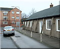
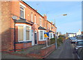
6
Church Drive, Arnold, Notts.
Former brewery workers' houses associated with the nearby Home Brewery.
Image: © David Hallam-Jones
Taken: 26 Dec 2017
0.11 miles
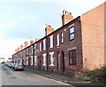
7
Church Drive, Arnold, Notts.
A number of the fairly substantial (4-5 bedroomed) Victorian semi-detached houses on Church Drive looking in the St Alban's Road direction. Interestingly, the housing stock on the other side of the road is a long - almost continuous - row of smaller terraced houses, presumably built later.
Image: © David Hallam-Jones
Taken: 12 Jan 2014
0.12 miles
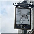
8
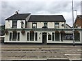
The Greyhound Inn
Nottingham Road, Arnold.
Image: © David Lally
Taken: 23 Aug 2018
0.12 miles
10
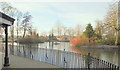
Duck Pond, Arnot Hill Park, Arnold, Notts.
A view towards Nottingham Road across a former mill pond. Robert Davison and John Hawkesley, partners in a worsted manufacturing business, owned a mill in Basford. This burnt down in 1791 whereupon they had an even bigger mill built on a plot of ground contiguous to the east side of Nottingham Road, Arnold on an estate known as Arnot Hill. This mill was the biggest in Gt Britain at the time with a workforce of 600 employees and 400 apprentices. The death of Davison, some heavy financial losses in 1809 and the already "encumbered state of the business", caused its closure in the early C19th.
Image: © David Hallam-Jones
Taken: 12 Jan 2014
0.13 miles