IMAGES TAKEN NEAR TO
Milford Court, NOTTINGHAM, NG5 6AQ
Introduction
This page details the photographs taken nearby to Milford Court, NG5 6AQ by members of the Geograph project.
The Geograph project started in 2005 with the aim of publishing, organising and preserving representative images for every square kilometre of Great Britain, Ireland and the Isle of Man.

There are currently over 7.5m images from over14,400 individuals and you can help contribute to the project by visiting https://www.geograph.org.uk
Image Map
Images are licensed for reuse under creativecommons.org/licenses/by-sa/2.0
Notes
- Clicking on the map will re-center to the selected point.
- The higher the marker number, the further away the image location is from the centre of the postcode.
Image Listing (79 Images Found)
Images are licensed for reuse under creativecommons.org/licenses/by-sa/2.0
Image
Details
Distance
1
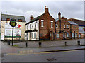
The former Grove at Daybrook
Boarded up pub. The car wash has disappeared as well.
Image: © Alan Murray-Rust
Taken: 18 Mar 2014
0.11 miles
2
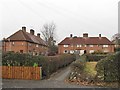
Typical 'twitchell' of Nottingham City Council houses
Nottingham Borough Council built a huge number of council houses between the 1920s and the early 1950s. The bulk of them were built to a limited number of designs which can be found all over the city.
The eight houses here represent one of the commoner designs: a terrace of four houses with a central arch giving access to the back gardens of the central houses.
Houses grouped along a pedestrian footway (usually known locally as a twitchell) are also a characteristic feature of the design of the estates where most of this housing was built.
Also visible are the original picket fences: usually supplemented, as here, with privet hedges.
Image: © SK53
Taken: 4 Jan 2011
0.12 miles
4
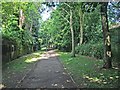
Daybrook: footpath to Edwards Lane
This path skirts the site of Daybrook railway station (closed 1960). The station was to the right, with the Bero flour factory immediately to the north of it. The back gardens of the houses on Bedale Road are on the left.
Image: © John Sutton
Taken: 25 Jun 2013
0.12 miles
5
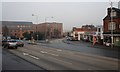
Junction of Nottingham Road with Mansfield Road
Nottingham Road is opposite heading to Arnold.
Image: © Mick Garratt
Taken: 23 Dec 2007
0.13 miles
6
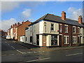
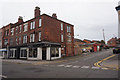
Corner shop
On the corner of Edwin Street and Mansfield Road. Sells phone covers and personalised items.
Image: © Jonathan Thacker
Taken: 7 Dec 2015
0.13 miles
7
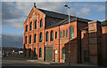
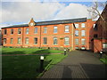
Morleys' Mill, Daybrook
A former textile factory, it later became a wire works and has now been converted to flats.
Image: © Alan Murray-Rust
Taken: 22 Jun 2008
0.13 miles
8
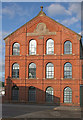
Morleys' Mill, Daybrook
Facade of the main building of 1885. Note the fine terracotta diaper work in the gable above the name. Another distinctive and unusual feature is the use of bullnosed bricks for all the window reveals giving a soft profile to the window openings.
Image: © Alan Murray-Rust
Taken: 22 Jun 2008
0.14 miles
9
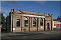
Former bank building, Daybrook Square
I have no idea which bank formerly owned this building.
Image: © Alan Murray-Rust
Taken: 22 Jun 2008
0.14 miles
10
Former J and R Morley hosiery factory
The original building http://www.britishlistedbuildings.co.uk/en-430399-former-j-and-r-morley-hosiery-factory-no#.VmXsQeKWMnA
Image: © Jonathan Thacker
Taken: 7 Dec 2015
0.14 miles