IMAGES TAKEN NEAR TO
Andover Road, NOTTINGHAM, NG5 5GA
Introduction
This page details the photographs taken nearby to Andover Road, NG5 5GA by members of the Geograph project.
The Geograph project started in 2005 with the aim of publishing, organising and preserving representative images for every square kilometre of Great Britain, Ireland and the Isle of Man.

There are currently over 7.5m images from over14,400 individuals and you can help contribute to the project by visiting https://www.geograph.org.uk
Image Map
Images are licensed for reuse under creativecommons.org/licenses/by-sa/2.0
Notes
- Clicking on the map will re-center to the selected point.
- The higher the marker number, the further away the image location is from the centre of the postcode.
Image Listing (15 Images Found)
Images are licensed for reuse under creativecommons.org/licenses/by-sa/2.0
Image
Details
Distance
1
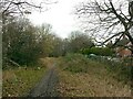
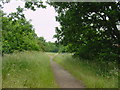
Old Railway Line
Recreating this 'First' for the square https://www.geograph.org.uk/photo/18879
Image: © Alan Murray-Rust
Taken: 8 Feb 2022
0.05 miles
2
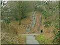
The site of Marble Arch
This was the local name given to a farm track accommodation bridge under the railway, later providing pedestrian access into Bestwood Estate. It was a tall narrow brick arch of similar proportions to the central opening of the London monument, hence the name. It was quite dark and was demolished following the closure of the railway, the line of which is now the Hucknall Road Walkway. The Walkway is a multi-user route; there is an alternative ramp to the left of the embankment - cyclists don't have to use the steps!
Image: © Alan Murray-Rust
Taken: 8 Feb 2022
0.07 miles
3
Kersall Drive: former railway bridge
The substantial blue-brick walls either side of Kersall Drive were, until 1968, the parapets of a bridge which crossed the Great Central Railway Nottingham-Sheffield main line. Bulwell Common South Junction was just to the right and Bulwell Common Station a little further north; to the left the main line ran south through New Basford to Nottingham Victoria and a line diverged to the west to Basford North (formerly Basford & Bulwell) Station. This bridge was wide as it crossed a number of tracks. Since closure the railway land has been redeveloped as housing. See Image] and Image] for other angles.
Image: © John Sutton
Taken: 6 May 2011
0.11 miles
4

Railway bridge parapet, Kersall Drive
The houses on the other side of this blue-brick wall are built on a filled-in cutting of what was once the Great Central Railway main line from Marylebone to Sheffield, via Leicester Central and Nottingham Victoria. This was the last main line to be built (1898) and the first to close (1966 as a through route and 1968 here to goods traffic). See Image] and Image] for other angles.
Image: © John Sutton
Taken: 6 May 2011
0.11 miles
5
Vestiges of the Great Central Railway
The blue-brick wall was once the parapet of a bridge which carried Kersall Drive over a number of tracks immediately south of Bulwell Common South Junction. The Great Central Railway main line from Marylebone to Sheffield, via Leicester Central and Nottingham Victoria was the last main line to be built (1898) and the first to close (1966 as a through route and 1968 here to goods traffic). Since closure the railway land has been redeveloped as housing. See Image] and Image] for other angles.
Image: © John Sutton
Taken: 6 May 2011
0.11 miles
6
Old Railway Line
Footpath along the old railway line parallel to A611
Image: © Q
Taken: 15 Jun 2005
0.12 miles
7
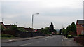
St Albans Road
The houses to the east of St Albans Road, and the closes behind them, are built on what was from 1898-1968 the site of the station and carriage and goods sidings at Bulwell Common, on the main line from Nottingham Victoria to Sheffield and Manchester. The secondary line which linked the Great Northern line at Basford North Station and Bulwell Common passed under the road roughly where I stood to take this picture.
Image: © John Sutton
Taken: 6 May 2011
0.12 miles
8
Former course of the Leen Valley Railway
The line of trees straight ahead marks the course of the Great Northern Railway's Leen Valley line, built in 1881 to serve collieries north of Nottingham and closed to passengers in 1929 and to all traffic in 1968. It is now a footpath beside Hucknall Road, on the eastern side of Bulwell Common.
Image: © John Sutton
Taken: 6 May 2011
0.16 miles
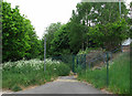
9

Bulwell NG5, Notts.
The commencement (or conclusion) of a footpath off Hucknall Road (the A611). The fence in the distance runs almost parallel with St Albans Road, Bulwell. The stones are two in a linear series of similar stones that have been installed in the gaps in the tree-line of a copse that runs parallel with Hucknall Road. It seems likely that the object of the stones is to prevent 'travellers' setting up camp here in what is known as Potter's Hollow Recreation Ground.
Image: © David Hallam-Jones
Taken: 17 May 2013
0.17 miles
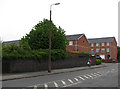
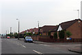
10

Southglade Road
Part of the Bestwood Estate development from the late 1930s
Image: © Alan Murray-Rust
Taken: 15 Mar 2009
0.19 miles