IMAGES TAKEN NEAR TO
Cavendish Vale, NOTTINGHAM, NG5 4DS
Introduction
This page details the photographs taken nearby to Cavendish Vale, NG5 4DS by members of the Geograph project.
The Geograph project started in 2005 with the aim of publishing, organising and preserving representative images for every square kilometre of Great Britain, Ireland and the Isle of Man.

There are currently over 7.5m images from over14,400 individuals and you can help contribute to the project by visiting https://www.geograph.org.uk
Image Map
Images are licensed for reuse under creativecommons.org/licenses/by-sa/2.0
Notes
- Clicking on the map will re-center to the selected point.
- The higher the marker number, the further away the image location is from the centre of the postcode.
Image Listing (82 Images Found)
Images are licensed for reuse under creativecommons.org/licenses/by-sa/2.0
Image
Details
Distance
1
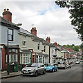
Sherwood Vale
Late 19th/early 20th century housing in Sherwood to the east of Mansfield Road.
Image: © Alan Murray-Rust
Taken: 8 Mar 2009
0.03 miles
2
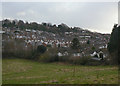
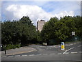
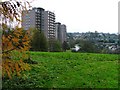
Cavendish Vale, Sherwood
Seen from Winchester Street, with Woodthorpe Court towering in the distance.
Image: © Richard Vince
Taken: 14 Jul 2012
0.06 miles
3
View from the bottom of Sherwood Vale
Looking towards the northern end of Sherwood from the lowest part of Sherwood Vale, where it links Mapperley Rise with Winchester Street.
Image: © Richard Vince
Taken: 14 Jul 2012
0.11 miles
4
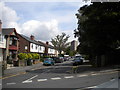
Sherwood: the top end of Dornoch Avenue
Behind the camera the road becomes Cresta Gardens, leading to Mapperley Rise and Sherwood Vale.
Image: © John Sutton
Taken: 17 Jun 2014
0.13 miles
5
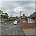
Sherwood: down Dornoch Avenue
One of the many steep streets on the hilly eastern side of the city.
Image: © John Sutton
Taken: 17 Jun 2014
0.13 miles
6
Woodthorpe flats from Mapperley Rise
High rise flats are relatively rare in Nottingham, particularly in north Nottingham. This block is one of two at the southern end of Woodthorpe Grange Park, sited where a station on the Nottingham Suburban Railway once was.
Image: © Richard Vince
Taken: 14 Jul 2012
0.13 miles
7
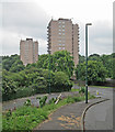
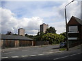
Sherwood: Woodthorpe Court and Winchester Court
The two tower blocks stand on the site of the short-lived Sherwood Station on the Nottingham Suburban Railway, open to passengers from 1889-1916 and to goods until 1951.
Image: © John Sutton
Taken: 17 Jun 2014
0.13 miles
8
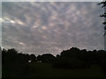
Harlequin Sky Over Woodthorpe Grange
This Park offers some sweeping views over the North of the city and beyond...
Image: © Tim Hallam
Taken: 14 Jun 2006
0.13 miles
9
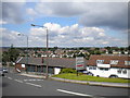
Blocks of Flats, Sherwood Station
Although the photograph was taken from SK5743 (just) it seems more appropriate to allocate this to SK5843 as that is the square the two blocks of flats, built on the site of the former Sherwood railway station, are in. The view is east towards Mapperlry Plains on the skyline.
Image: © Mick Garratt
Taken: 3 Dec 2005
0.13 miles
10
Woodthorpe flats from Sherwood Vale
Woodthorpe Court (left) and Winchester Court seen from the bottom of Sherwood Vale as it descends to meet Winchester Street.
Image: © Richard Vince
Taken: 14 Jul 2012
0.14 miles