IMAGES TAKEN NEAR TO
Briarwood Court, NOTTINGHAM, NG5 4BW
Introduction
This page details the photographs taken nearby to Briarwood Court, NG5 4BW by members of the Geograph project.
The Geograph project started in 2005 with the aim of publishing, organising and preserving representative images for every square kilometre of Great Britain, Ireland and the Isle of Man.

There are currently over 7.5m images from over14,400 individuals and you can help contribute to the project by visiting https://www.geograph.org.uk
Image Map
Images are licensed for reuse under creativecommons.org/licenses/by-sa/2.0
Notes
- Clicking on the map will re-center to the selected point.
- The higher the marker number, the further away the image location is from the centre of the postcode.
Image Listing (72 Images Found)
Images are licensed for reuse under creativecommons.org/licenses/by-sa/2.0
Image
Details
Distance
1

Sherwood Station site
Without the bridge in the background, there would be no clue to the fact that 60 years ago I would have been standing in the middle of a railway.
Image: © Alan Murray-Rust
Taken: 8 Mar 2009
0.03 miles
2
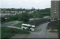
Bus at Winchester Court
This picture complements the modern version Image
The location is not identical, because when the service first started in 1986 it used the garage road to the south of Winchester Court, as this was the only adequate route. The concept of a regular bus service being routed through a garage yard like this probably would not occur to most people!
This is one of a series of views featuring buses in the 60s, 70s, and 80s. http://www.geograph.org.uk/search.php?i=2114547&displayclass=slide
Image: © Alan Murray-Rust
Taken: Unknown
0.03 miles
3
Sherwood Vale: the parapets of Bridge No 11
The blue brick parapets topped the Nottingham Suburban Railway's Bridge No 11, an arched 40ft span. Sherwood Station was to the right (for its site see Image]) and the deep cutting to the north of Sherwood Tunnel, now entirely choked with trees, to the left. Alan Murray-Rust's Image] shows the bridge from what was once rail level.
Image: © John Sutton
Taken: 17 Jun 2014
0.03 miles
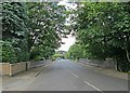
4
Sherwood Vale railway bridge
The bridge was over the old Nottingham Suburban railway.
Image: © Alan Murray-Rust
Taken: 8 Mar 2009
0.03 miles
5
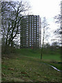
Woodthorpe flats from Mapperley Rise
High rise flats are relatively rare in Nottingham, particularly in north Nottingham. This block is one of two at the southern end of Woodthorpe Grange Park, sited where a station on the Nottingham Suburban Railway once was.
Image: © Richard Vince
Taken: 14 Jul 2012
0.04 miles
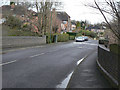
6

Nos. 70 & 68 Mapperley Rise at Sherwood Rise junction
Image: © Roger Templeman
Taken: 1 Feb 2020
0.05 miles
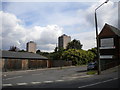
7
Winchester Court
One of the pair of tower blocks built on the site of Sherwood Station. In the early 1980s they were refurbished for elderly persons.
Image: © Alan Murray-Rust
Taken: 8 Mar 2009
0.05 miles
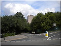
8
Woodthorpe flats from Sherwood Vale
Woodthorpe Court (left) and Winchester Court seen from the bottom of Sherwood Vale as it descends to meet Winchester Street.
Image: © Richard Vince
Taken: 14 Jul 2012
0.06 miles
9
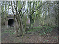
Brickworks tramroad
The tramroad came down an incline from Mapperley brickworks under the bridge to Sherwood Station where products would be transhipped on to the railway network. This is the most significant remaining structure associated with the extensive brickmaking industry in east Nottingham, based on the local clays and mudstones.
Image: © Alan Murray-Rust
Taken: 8 Mar 2009
0.06 miles
10
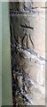
Benchmark behind cabinet on SW side of Mapperley Rise
Ordnance Survey cut mark benchmark levelled at 92.345m above Newlyn Datum verified 1962
Image: © Roger Templeman
Taken: 8 May 2022
0.06 miles