IMAGES TAKEN NEAR TO
Valley Road, NOTTINGHAM, NG5 3HQ
Introduction
This page details the photographs taken nearby to Valley Road, NG5 3HQ by members of the Geograph project.
The Geograph project started in 2005 with the aim of publishing, organising and preserving representative images for every square kilometre of Great Britain, Ireland and the Isle of Man.

There are currently over 7.5m images from over14,400 individuals and you can help contribute to the project by visiting https://www.geograph.org.uk
Image Map
Images are licensed for reuse under creativecommons.org/licenses/by-sa/2.0
Notes
- Clicking on the map will re-center to the selected point.
- The higher the marker number, the further away the image location is from the centre of the postcode.
Image Listing (77 Images Found)
Images are licensed for reuse under creativecommons.org/licenses/by-sa/2.0
Image
Details
Distance
1
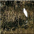
Wildlife in Valley Road Park
I was very surprised to find a Little Egret and a pair of Teal (note the green flash of the male top left) in what is still very much an urban environment.
Image: © Alan Murray-Rust
Taken: 26 Jan 2022
0.04 miles
2
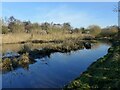
The Day Brook in Valley Road Park
A pond-like section with wetland characteristics.
Image: © Alan Murray-Rust
Taken: 26 Jan 2022
0.05 miles
3
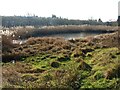
Pond in Valley Road Park
Part of the most easterly section of this linear park which has been allowed to develop a natural wetland habitat.
Image: © Alan Murray-Rust
Taken: 26 Jan 2022
0.05 miles
4
The Day Brook in Valley Road Park
A pond-like section with wetland characteristics.
Image: © Alan Murray-Rust
Taken: 26 Jan 2022
0.06 miles
5
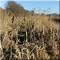
Typha latifolia and phragmites australis
Growing close together in Valley Road Park – a view for comparison of the two species. Typha in the foreground with phragmites behind.
Image: © Alan Murray-Rust
Taken: 26 Jan 2022
0.06 miles
6
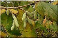
Hazel catkins
Due to the warm autumn, the catkins are well advanced even before all the leaves have fallen.
Image: © Alan Murray-Rust
Taken: 2 Dec 2022
0.07 miles
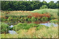
7
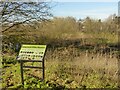
Valley Road Water Meadow
Created by diverting the Day Brook to a meandering course with small ponds in around 2008 as a flood alleviation scheme, the area has developed more of a wetland ecology with extensive reed-beds. The intention of attracting more diverse wildlife, as indicated on the board, has however been fulfilled.
Image: © Alan Murray-Rust
Taken: 26 Jan 2022
0.07 miles
8
Wetlands in Valley Park
The path follows the original line of the Day Brook which was diverted into a meandering course, through what was intended as a water meadow, as flood alleviation measures. It has developed more of a wetland ecology since.
Image: © Alan Murray-Rust
Taken: 26 Jan 2022
0.08 miles
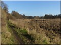
9
Valley Road Park Flood Plain, Nottingham NG5
This long, thin, sausage-shaped park is known as Day Brook Recreation Ground at its other end. Here, at its Mansfield Road end it is called Valley Road Park. Nonetheless the footpath, seen here passing the Day Brook flood plain (or flood fringe), is actually an almost continuous path between the Valley Rd/Mansfield Rd junction entrance and its Edwards Lane exit. Valley Road (the A6514) runs behind the tree line directly ahead.
Image: © David Hallam-Jones
Taken: 12 Jul 2014
0.09 miles
10
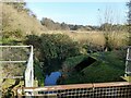
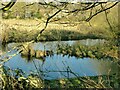
The Day Brook in Valley Road Park
This section was converted from grassland to a water meadow in around 2008 as a flood alleviation measure. Previously the brook ran in a narrow straight channel along the line of the hedge to the left. The structure in the foreground previously acted to reduce flow to some extent.
Image: © Alan Murray-Rust
Taken: 26 Jan 2022
0.09 miles