IMAGES TAKEN NEAR TO
Mansfield Road, NOTTINGHAM, NG5 3GG
Introduction
This page details the photographs taken nearby to Mansfield Road, NG5 3GG by members of the Geograph project.
The Geograph project started in 2005 with the aim of publishing, organising and preserving representative images for every square kilometre of Great Britain, Ireland and the Isle of Man.

There are currently over 7.5m images from over14,400 individuals and you can help contribute to the project by visiting https://www.geograph.org.uk
Image Map
Images are licensed for reuse under creativecommons.org/licenses/by-sa/2.0
Notes
- Clicking on the map will re-center to the selected point.
- The higher the marker number, the further away the image location is from the centre of the postcode.
Image Listing (80 Images Found)
Images are licensed for reuse under creativecommons.org/licenses/by-sa/2.0
Image
Details
Distance
1
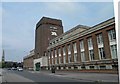
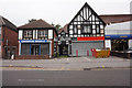
Home of The Best?
Site of the former Home Brewery Mansfield Road Nottingham.
Image: © Steve Fareham
Taken: 18 May 2012
0.03 miles
2
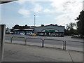
View to Pets at Home, Arnold, Nottingham
A well known pet superstore viewed from a BP filling station.
Image: © Jeremy Bolwell
Taken: 10 Aug 2020
0.03 miles
3
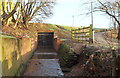
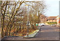
The Day Brook, Arnold, Notts.
The Day Brook exiting a tunnel built to carry it underneath a service road that connects the side of a B&Q DIY store with a car parking area that is used by various retail and industrial units situated in the top right-hand corner of this picture. Day Brook passes through what is now known as the Daybrook area and continues on to empty into the River Leen in Basford. The footpath here is seen descending into Thackeray's Road Recreation Ground.
Image: © David Hallam-Jones
Taken: 12 Jan 2014
0.04 miles
4
Day Brook at Woodthorpe Park
Culverted under the former railway embankment, from which the picture was taken, the Day Brook emerges in the corner of the small park at the corner of Mansfield Road and Thackerays Lane, skirts it, then tunnels under Mansfield Road on its way to Valley Road and beyond.
Image: © John Sutton
Taken: 18 May 2010
0.04 miles
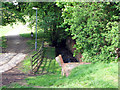
5
Daybrook, Borough of Gedling, Notts.
A tunnel beneath this service road allows water in the Day brook to continue flowing along the edge of Thackeray's Lane Recreation Ground before it passes beneath the Mansfield Road (the A60 road) and into Valley Road Recreation Ground. This service road branches off Mansfield Roadside (ahead); passes the side of a B&Q DIY store on the right; crosses over the Day brook tunnel and continues until it joins a car parking area behind the photographer. The car park is used by various retail and small industrial units. The Day Brook passes through the Daybrook area and continues on to empty into the River Leen in Basford. The footpath on the left descends into Thackeray's Road Recreation Ground.
Image: © David Hallam-Jones
Taken: 12 Jan 2014
0.05 miles
6
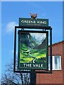
The sign of The Vale
Somewhat more idilic than its actual setting.
Fuller view of the pub: Image
Image: © David Lally
Taken: 2 Apr 2024
0.06 miles
7
The site of Daybrook Junction
Until 1960, the path straight ahead was the track of the Great Northern Railway's line to Derby, always known as The Back Line as it circled Nottingham to the east, carrying Erewash Valley coal to the marshalling yards at Colwick. The short-lived Nottingham Suburban Railway, whose passenger service lasted only from 1889-1931, but which remained open until 1951 to serve Mapperley brickworks, diverged on an embankment to the right, passing through Woodthorpe Grange Park and serving stations at Sherwood, St Ann's Well and Thorneywood before joining the Grantham line at Trent Lane Junction, trains terminating at London Road. Its course through Woodthorpe is marked by the curve of Worcester Road, while further south the almost appropriately-named Raibank Gardens is built on the trackbed. Daybrook B&Q, behind the camera, stands where the two lines actually joined. Most of the embankment there has been levelled (and the bridge over Mansfield Road removed), so the steps in the foreground lead up to what used to be rail level.
Image: © John Sutton
Taken: 18 May 2010
0.06 miles
8
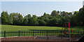
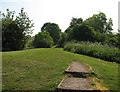
Woodthorpe Park - once a cricket ground
The small park behind The Vale public house at the corner of Mansfield Road and Thackerays Lane was once home to Woodthorpe Cricket Club, for which I played in the late 1960s. There is no sign of a wicket now, or of the tennis courts which restricted the width of the cricket field - which also had such short straight boundaries that it was only a delicate chip for a six into the garden of the club president, on Park Road, to the right. The trees in the background are growing on the embankment of the
short-lived Nottingham Suburban Railway, whose passenger service lasted only from 1889-1931, but which remained open until 1951 to serve Mapperley brickworks. It curved south from Daybrook Junction (just offstage left, where B&Q now stands) and passed through and under Woodthorpe Grange Park, serving stations at Sherwood and Thorneywood, before joining the Grantham line at Trent Lane Junction, trains terminating at London Road. Its course through Woodthorpe is marked by the curve of Worcester Road, while further south the almost appropriately-named Raibank Gardens is built on the trackbed.
Image: © John Sutton
Taken: 18 May 2010
0.07 miles
10
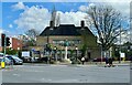
The Vale
Substantial public house from the 1930s.
One might assume as it is now a Greene King establishment that it was a Kimberly Ales (Hardy Hanson) tied house. However it was designed by T Cecil Howitt of Nottingham, for Home Ales Brewery. While it still sports the text-only sign on the substantial fluted column Image, it now also has a somewhat romantic vision of a mountain vale on a sign at the car park entrance on Mansfield Road Image
It has a Grade II listing List Entry Number:1255455 https://historicengland.org.uk/listing/the-list/list-entry/1255455?section=official-list-entry.
Image: © David Lally
Taken: 2 Apr 2024
0.08 miles