
IMAGES TAKEN NEAR TO
Gunthorpe Drive, NOTTINGHAM, NG5 3DT
Introduction
This page details the photographs taken nearby to Gunthorpe Drive, NG5 3DT by members of the Geograph project.
The Geograph project started in 2005 with the aim of publishing, organising and preserving representative images for every square kilometre of Great Britain, Ireland and the Isle of Man.

There are currently over 7.5m images from over14,400 individuals and you can help contribute to the project by visiting https://www.geograph.org.uk
Image Map
Images are licensed for reuse under creativecommons.org/licenses/by-sa/2.0
Notes
- Clicking on the map will re-center to the selected point.
- The higher the marker number, the further away the image location is from the centre of the postcode.
Image Listing (52 Images Found)
Images are licensed for reuse under creativecommons.org/licenses/by-sa/2.0
Image
Details
Distance
1
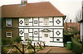
16, Kneeton Vale, Sherwood
My parents' house for a few years; this picture was taken shortly before the purchase. The ridiculous Tudor-style decoration was installed by the previous owner, inadvertently resembling maritime signal flags somewhat. All of this was taken down shortly after the purchase, needless to say!
Image: © Stephen Mills
Taken: Unknown
0.12 miles
2
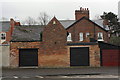
Garages on Perry Road
There is an OS benchmark Image on the bricks to the left of the left hand side garage door
Image: © Roger Templeman
Taken: 9 Apr 2012
0.14 miles
3
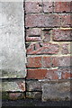
Benchmark on garage at rear of Burlington Road house
Ordnance Survey cut mark benchmark described on the Bench Mark Database at http://www.bench-marks.org.uk/bm42703
Image: © Roger Templeman
Taken: 9 Apr 2012
0.14 miles
4
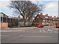
Nottingham - Bagthorpe
A view of the junction of Gunthorpe Drive with Perry Rd, NG5. On the left is part of HMP Nottingham that began life as Bagthorpe Gaol in 1890. It was rebuilt in 1912 and functioned as a closed training establishment for men until 1997. Its latest metamorphosis was in 2008 when it was reconstructed again and redoubled in size.
Image: © David Hallam-Jones
Taken: 21 Mar 2012
0.14 miles
5
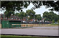
Valley Road Park, Nottingham, NG5
This recreation ground is situated between Day Brook, a river that acts as a natural boundary between City Hospital (off screen on the left) and the A6514 (to the left of the railings). The series of lamp posts bordering these Nottingham Petanque Club’s pistes once provided external lighting on the P.Z.Cussons (U.K. Ltd) soap factory site in Basford. Gerard Bros Ltd opened a soap manufacturing factory in 1893 and it was taken over by Cussons Ltd in 1955. When Cussons closed the factory in 2009, having decided to shift its production elsewhere, one of the founding members of the petanque club asked if the club might have the lamp posts as an alternative to them ending up as scrap metal. The newly installed club storage premises can be seen here.
Image: © David Hallam-Jones
Taken: 12 Jul 2014
0.15 miles
6
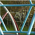
Tubular patterns
Climbing frames in Valley Road Park play area.
Image: © Alan Murray-Rust
Taken: 2 Dec 2022
0.17 miles
7

Valley Road Park ? boules
In the foreground are petanque or boules courts; the City Hospital forms the backdrop.
Image: © Alan Murray-Rust
Taken: 18 Jan 2022
0.17 miles
8

Valley Road Park ? skate park ? 1
Skate parks are one of the few places where graffiti are accepted as part of the culture.
Image: © Alan Murray-Rust
Taken: 18 Jan 2022
0.17 miles
9

Valley Road Park ? bullet proof
Graffiti on the skate park. Deliberately underexposed to offset the sunshine reflecting off the silver paint.
Image: © Alan Murray-Rust
Taken: 18 Jan 2022
0.17 miles
10
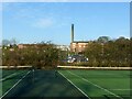
Valley Road Park ? anyone for tennis? - 2
Hard surface tennis courts with City Hospital as the backdrop.
Image: © Alan Murray-Rust
Taken: 18 Jan 2022
0.18 miles