IMAGES TAKEN NEAR TO
Gamston Crescent, NOTTINGHAM, NG5 3DN
Introduction
This page details the photographs taken nearby to Gamston Crescent, NG5 3DN by members of the Geograph project.
The Geograph project started in 2005 with the aim of publishing, organising and preserving representative images for every square kilometre of Great Britain, Ireland and the Isle of Man.

There are currently over 7.5m images from over14,400 individuals and you can help contribute to the project by visiting https://www.geograph.org.uk
Image Map
Images are licensed for reuse under creativecommons.org/licenses/by-sa/2.0
Notes
- Clicking on the map will re-center to the selected point.
- The higher the marker number, the further away the image location is from the centre of the postcode.
Image Listing (46 Images Found)
Images are licensed for reuse under creativecommons.org/licenses/by-sa/2.0
Image
Details
Distance
1
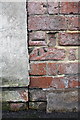
Benchmark on garage at rear of Burlington Road house
Ordnance Survey cut mark benchmark described on the Bench Mark Database at http://www.bench-marks.org.uk/bm42703
Image: © Roger Templeman
Taken: 9 Apr 2012
0.09 miles
2
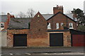
Garages on Perry Road
There is an OS benchmark Image on the bricks to the left of the left hand side garage door
Image: © Roger Templeman
Taken: 9 Apr 2012
0.09 miles
3
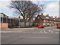
Nottingham - Bagthorpe
A view of the junction of Gunthorpe Drive with Perry Rd, NG5. On the left is part of HMP Nottingham that began life as Bagthorpe Gaol in 1890. It was rebuilt in 1912 and functioned as a closed training establishment for men until 1997. Its latest metamorphosis was in 2008 when it was reconstructed again and redoubled in size.
Image: © David Hallam-Jones
Taken: 21 Mar 2012
0.13 miles
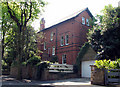
4
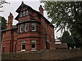
Watson Fothergill's Burlington Tower
Taken just before having a lovely chat with the current owner who after is in the process of restoring this to a single residency from its previous state split into flats.
They have also cleared the vegetation that used to obscure this fine example of WF's work. For peeks of it previously see Image Image Image
Image: © David Lally
Taken: 5 Aug 2017
0.14 miles
5
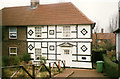
16, Kneeton Vale, Sherwood
My parents' house for a few years; this picture was taken shortly before the purchase. The ridiculous Tudor-style decoration was installed by the previous owner, inadvertently resembling maritime signal flags somewhat. All of this was taken down shortly after the purchase, needless to say!
Image: © Stephen Mills
Taken: Unknown
0.14 miles
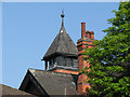
6
Watson Fothergill's Burlington Tower - 3
Burlington Tower (1899), on Burlington Road, is a typically grand Fothergill house, but difficult to photograph as it turns its back to the road and is surrounded by trees. The terra cotta dragon ridge tile and herringbone brick-nogging are characteristic of Fothergill.
Image: © John Sutton
Taken: 18 May 2010
0.15 miles
7
Watson Fothergill's Burlington Tower - 2
Burlington Tower presents its rather plain side and rear to Burlington Road. The more extravagant and characteristic elevations and features are largely concealed from the passing Fothergill enthusiast, or hidden by trees.
Image: © John Sutton
Taken: 18 May 2010
0.15 miles
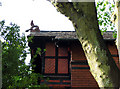
8
Watson Fothergill's Burlington Tower - 1
Most of the grander features of Burlington Tower are hidden by trees and a modern bungalow, part of whose roof appears in the bottom left corner. The tower has a typical Fothergill finial, but is plainer than some of his more outlandish turrets and spires.
Image: © John Sutton
Taken: 18 May 2010
0.15 miles
9
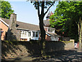
Burlington Road, Sherwood
This bungalow is untypical of a tree-shaded road of very grand Victorian houses, including Watson Fothergill's Burlington Tower (1899), part of which shows through the foliage above the bungalow dormer.
Image: © John Sutton
Taken: 18 May 2010
0.15 miles
10
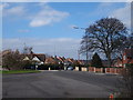
Nottingham - NG5
A view of the roundabout at the Mansfield Road end of Edwards Lane. A stationary car sits on a lower section of Edwards Lane. This busy bus route carries passengers and other traffic to & from the City Hospital and Valley Rd area of NG5. Behind the magnolia tree is a section of Perry Road leading in the direction of HMP Nottingham and Hucknall Rd (A611).
Image: © David Hallam-Jones
Taken: 21 Mar 2012
0.16 miles