IMAGES TAKEN NEAR TO
Magnus Road, NOTTINGHAM, NG5 3AB
Introduction
This page details the photographs taken nearby to Magnus Road, NG5 3AB by members of the Geograph project.
The Geograph project started in 2005 with the aim of publishing, organising and preserving representative images for every square kilometre of Great Britain, Ireland and the Isle of Man.

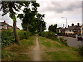
There are currently over 7.5m images from over14,400 individuals and you can help contribute to the project by visiting https://www.geograph.org.uk
Image Map
Images are licensed for reuse under creativecommons.org/licenses/by-sa/2.0
Notes
- Clicking on the map will re-center to the selected point.
- The higher the marker number, the further away the image location is from the centre of the postcode.
Image Listing (63 Images Found)
Images are licensed for reuse under creativecommons.org/licenses/by-sa/2.0
Image
Details
Distance
1
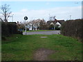
Nottingham - Sherwood
A view of the Edwards Lane roundabout with Mansfield Rd (A60) and the main Sherwood shopping area lying behind the photographer. In the foreground is a footpath that forms a thin, finger-like stretch of common land that sits in the centre of Edwards Lane.
Image: © David Hallam-Jones
Taken: 21 Mar 2012
0.04 miles
2
Edwards Lane
Recreating this 'First' for the square https://www.geograph.org.uk/photo/18536 . Strictly this is Magnus Road, with Edwards Lane on the other side of the left hand hedge, but the two effectively are a dual carriageway with this wide central reservation.
Image: © Alan Murray-Rust
Taken: 20 Jul 2021
0.04 miles
3
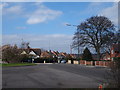
Nottingham - NG5
A view of the roundabout at the Mansfield Road end of Edwards Lane. A stationary car sits on a lower section of Edwards Lane. This busy bus route carries passengers and other traffic to & from the City Hospital and Valley Rd area of NG5. Behind the magnolia tree is a section of Perry Road leading in the direction of HMP Nottingham and Hucknall Rd (A611).
Image: © David Hallam-Jones
Taken: 21 Mar 2012
0.05 miles
4
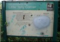
Little Holly Corner Nature Reserve - Information Board
Image: © Oxymoron
Taken: 17 Aug 2008
0.05 miles
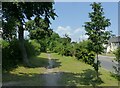
5
Edwards Lane
Pathway up the centre of Edwards Lane
Image: © Q
Taken: 14 Jun 2005
0.06 miles
6
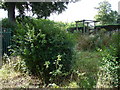
Little Holly Corner Nature Reserve
The smallest (about 100 square metres) nature reserve administered by the Wildlife Trusts.
Image: © Oxymoron
Taken: 17 Aug 2008
0.06 miles
7
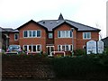
The Firs Home for the Elderly
Between 1941 and 1982 this was a maternity home. Today it is being completely renovated and extended and is a care home for the elderly.
Image: © Mick Garratt
Taken: 3 Dec 2005
0.08 miles
8
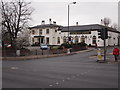
Nottingham - Sherwood NG5
A view of "The Sherwood Manor" pub at the junction of Mansfield Rd (A60) and Edwards Lane. Formerly known as "The Garden City" public house.
Image: © David Hallam-Jones
Taken: 16 Mar 2012
0.09 miles
9
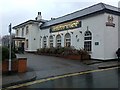
Sherwood Manor
Former Hardy Hanson's (Kimberley) pub on the corner of Mansfield Road and Edwards Lane. Now converted by Greene King to form part of their Hungry Horse chain.
Image: © David Lally
Taken: 30 Dec 2009
0.09 miles
10
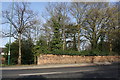
Brick wall on northwest side of Mansfield Road
There is an Ordnance Survey benchmark Image near the left hand end of the wall
Image: © Luke Shaw
Taken: 1 Apr 2019
0.10 miles