IMAGES TAKEN NEAR TO
May Court, NOTTINGHAM, NG5 2BG
Introduction
This page details the photographs taken nearby to May Court, NG5 2BG by members of the Geograph project.
The Geograph project started in 2005 with the aim of publishing, organising and preserving representative images for every square kilometre of Great Britain, Ireland and the Isle of Man.

There are currently over 7.5m images from over14,400 individuals and you can help contribute to the project by visiting https://www.geograph.org.uk
Image Map
Images are licensed for reuse under creativecommons.org/licenses/by-sa/2.0
Notes
- Clicking on the map will re-center to the selected point.
- The higher the marker number, the further away the image location is from the centre of the postcode.
Image Listing (142 Images Found)
Images are licensed for reuse under creativecommons.org/licenses/by-sa/2.0
Image
Details
Distance
1
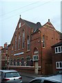
Apostolic Church
The Mount Beulah Apostolic Church is located in Sherbrooke Road.
Image: © Michael Dibb
Taken: 30 Mar 2017
0.02 miles
2
Nottingham, NG5 - "Sherrington"
The closed end of Welsley Street (a cul-de-sac) off Oak Street, the latter being close to the back of the former Carrington Post Office, a victim of the 2007/08 cut-backs.
Image: © David Hallam-Jones
Taken: 4 Nov 2012
0.02 miles
3
Nottingham, NG5 - "Carrington"
A path that connects Wesley Street, Carrington with Hucknall Road, Carrington taken from the closed end of Welsley Street (a cul-de-sac). The red brick building on the right is used jointly by the 2418 (Sherwood) Squadron/Air Training Corps and the Sherwood Army Cadet Force whereas the building beyond it is a British Telecom depot. with an entrance off Wesley Street in the distance. The playing field on the left belongs to neighbouring Carrington Primary and Nursery School.
Image: © David Hallam-Jones
Taken: 4 Nov 2012
0.03 miles
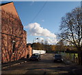
4
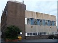
Another ugly BT building
A strong contender for the title of ugliest building in Nottingham, this hideous structure is in Hucknall Road.
Image: © Michael Dibb
Taken: 30 Mar 2017
0.03 miles
5
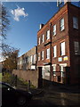
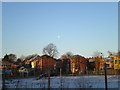
Buildings on Wesley Street from Loscoe Road
A view across a small patch of wasteland to the backs of houses and a factory that are both at right angles to Wesley Street. The houses to the left, beyond the tree, are on Ebury Road, which is just off Hucknall Road.
Image: © Richard Vince
Taken: 4 Jan 2010
0.03 miles
6
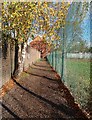
Nottingham, NG5 - "Carrington"
The path that connects Hucknall Road, with Wesley Street, Carrington. The boundary wall belongs jointly to the British Telecom depot and premises used jointly by the 2418 (Sherwood) Squadron/Air Training Corps and the Sherwood Army Cadet Force, with an entrance off Wesley Street in the distance. The playing field on the right belongs to neighbouring Carrington Primary and Nursery School.
Image: © David Hallam-Jones
Taken: 4 Nov 2012
0.03 miles
7
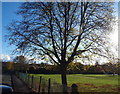
Nottingham, NG5 - "Sherrington"
A view of the Wesley Street side of a playing field belonging to Carrington Primary and Nursery School. A distant car marks the school's entrance on Hucknall Road. This picture was taken with the closed end of Wesley Street (a cul-de-sac) behind the photographer.
Image: © David Hallam-Jones
Taken: 4 Nov 2012
0.04 miles
8
Nottingham, NG5 -"Sherrington"
A view of the straight stretch of Welsley Street taken with the closed end of it (a cul-de-sac) behind the photographer. In the distance a 90 degree turn to the left makes a connection with Oak Street, the latter being close to the back of the former Carrington Post Office, a victim of the 2010/11 cut-backs. The playing field belongs to Carrington Primary and Nursery School situated on Hucknall Road and the run of canvas sheeting clipped to the fencing on the left represents an attempt to keep children using the playing field and construction workers on the building site - behind the fencing - from seeing each other!
Image: © David Hallam-Jones
Taken: 4 Nov 2012
0.04 miles
9
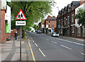
Hucknall Road, Carrington
Looking north towards the crest of the ridge. Claremont Road is on the left.
Image: © John Sutton
Taken: 27 Apr 2011
0.05 miles
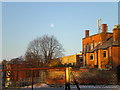
10
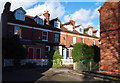
Houses on Ebury Road, from Loscoe Road
The fairly imposing three storey houses near the centre of the picture are at the east end of Ebury Road as it joins Hucknall Road. They are seen from Loscoe Road across (in order of proximity to the photographer) a patch of wasteground, Wesley Street, and the playing field of Carrington Primary School.
Image: © Richard Vince
Taken: 4 Jan 2010
0.05 miles