IMAGES TAKEN NEAR TO
Morley Gardens, NOTTINGHAM, NG5 2AZ
Introduction
This page details the photographs taken nearby to Morley Gardens, NG5 2AZ by members of the Geograph project.
The Geograph project started in 2005 with the aim of publishing, organising and preserving representative images for every square kilometre of Great Britain, Ireland and the Isle of Man.

There are currently over 7.5m images from over14,400 individuals and you can help contribute to the project by visiting https://www.geograph.org.uk
Image Map
Images are licensed for reuse under creativecommons.org/licenses/by-sa/2.0
Notes
- Clicking on the map will re-center to the selected point.
- The higher the marker number, the further away the image location is from the centre of the postcode.
Image Listing (164 Images Found)
Images are licensed for reuse under creativecommons.org/licenses/by-sa/2.0
Image
Details
Distance
1
Nottingham - Carrington, NG5
A view of the entrance into the "Secret Garden" (or the 'less-well-known garden') off Church Drive Carrington, opposite one of the Carrington Pottery shop windows. Once a very small children's playground with swings etc, it is now a small garden.
Image: © David Hallam-Jones
Taken: 15 Mar 2012
0.02 miles
2
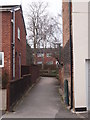
Start of path
The public footpath leads to Michael Gardens.
Image: © Michael Dibb
Taken: 30 Mar 2017
0.02 miles
3
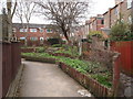
Carrington Community Garden
The Community Garden straddles a twitchel between Bernard Street and Church Drive (ahead). In the background are three-storey houses on Loscoe Road.
Image: © John Sutton
Taken: 14 Jun 2023
0.02 miles
4
Nottingham - Carrington NG5
A view of a small public garden off Church Drive, Carrington. The entrance is directly opposite the Church Drive shop window of the Carrington Pottery. This area was a children's play area containing a few pieces of playground equipment. These however, seem to have been superseded by this small "secret garden".
Image: © David Hallam-Jones
Taken: 15 Mar 2012
0.02 miles
5
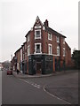
Nottingham - Carrington
Carrington Pottery at 15-17, Church Drive, NG5 sits at the junction between Church Drive on the right and Loscoe Road on the left.
Image: © David Hallam-Jones
Taken: 15 Mar 2012
0.02 miles
6

Carrington: Church Drive
Church Drive runs from Mansfield Road to Hucknall Road (ahead). This stretch has a mixture of Victorian and twentieth-century houses.
Image: © John Sutton
Taken: 14 Jun 2023
0.03 miles
7
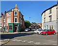
Carrington: at the corner of Loscoe Road and Church Drive
Carrington is a Victorian suburb to the north of the centre of Nottingham.
Image: © John Sutton
Taken: 14 Jun 2023
0.03 miles
8
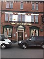
The Gladstone
The Gladstone, Loscoe Road, Carrington, Nottingham. A fine traditional English pub that has won numerous Nottingham in Bloom prizes for its flower displays in the rear courtyard.
Image: © Neil Hill
Taken: 30 Mar 2013
0.03 miles
9

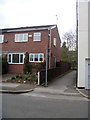
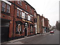
Corner pottery
This lovely corner property bears a datestone of 1891.
Image: © Michael Dibb
Taken: 30 Mar 2017
0.03 miles
10
Nottingham - Carrington
A view of Loscoe Road NG5 showing "The Gladstone Hotel" on the right. Built in 1882, a previous landlord called George Fryer, an English amateur heavyweight boxing champion, was once billed as 'The Nottingham Slasher' when he fought in the USA. Adjacent to the red car are the Carrington Pottery premises. In the distance, although hardly visible, there is access on Watcombe Circus.
Image: © David Hallam-Jones
Taken: 15 Mar 2012
0.03 miles