IMAGES TAKEN NEAR TO
Lortas Road, NOTTINGHAM, NG5 1EH
Introduction
This page details the photographs taken nearby to Lortas Road, NG5 1EH by members of the Geograph project.
The Geograph project started in 2005 with the aim of publishing, organising and preserving representative images for every square kilometre of Great Britain, Ireland and the Isle of Man.

There are currently over 7.5m images from over14,400 individuals and you can help contribute to the project by visiting https://www.geograph.org.uk
Image Map
Images are licensed for reuse under creativecommons.org/licenses/by-sa/2.0
Notes
- Clicking on the map will re-center to the selected point.
- The higher the marker number, the further away the image location is from the centre of the postcode.
Image Listing (92 Images Found)
Images are licensed for reuse under creativecommons.org/licenses/by-sa/2.0
Image
Details
Distance
1
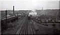
South from Perry Road bridge, 1963
This was a good place for trainspotting on a schoolday evening, and seeing a Gresley V2 2-6-2 coming towards me on a northbound pigeon special was enough to make me press the shutter (far too soon). Much of what appears in this picture no longer exists, including the carriage sheds to the left (the site of Sheridan Way), New Basford station (behind the train) and the factory chimney on the right horizon. The council houses on the right are on Glamis Avenue. The cutting in the foreground has been filled in and built on. The historical interest of the picture (scanned and cropped from a tiny square print) may make up for its technical shortcomings.
The Great Central Railway main line from London Marylebone to Sheffield via Leicester and Nottingham was the last trunk route to be completed (1899) and the first to close (1967). North of Nottingham and in the city much of its route has disappeared - embankments flattened, cuttings filled, viaducts demolished - and it is hard to follow.
Compare with Image
Image: © John Sutton
Taken: Unknown
0.09 miles
2
South from Perry Road, 2011
This picture, taken at arm's length over a high concrete wall (thank goodness for the digital camera's swivelling display screen), only makes sense if viewed as one of a pair, with Image], which shows the same scene nearly fifty years before. The houses behind the trees are on Sheridan Way, which is built on reclaimed railway land. The distant horizon on the right is the sandstone ridge which divides New Basford from Forest Fields.
Image: © John Sutton
Taken: 28 Apr 2011
0.09 miles
3
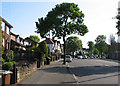
Perry Road
The Great Central Railway main line from London Marylebone to Sheffield via Leicester and Nottingham was the last trunk route to be completed (1899) and the first to close (1967). North of Nottingham and in the city much of its route has disappeared - embankments flattened, cuttings filled, viaducts demolished - and it is hard to follow. The best part of fifty years ago I used to cycle up here of an evening to watch the trains pass under Perry Road bridge. On the left the newer houses between the 1930s ones are on the site of the cutting shown in Image] and the concrete wall on the right (over which I took Image]) is the site of the bridge parapet from which Image] was taken.
Image: © John Sutton
Taken: 28 Apr 2011
0.12 miles

5
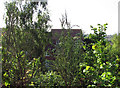
Basford Cemetery on a spring morning
Looking towards Perry Road. A corner of the derelict Bulwell stone chapel is on the extreme left.
Image: © John Sutton
Taken: 28 Apr 2011
0.14 miles
6
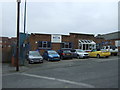
The Beck Company
Suppliers of copper tube and fittings. On Quorn Road.
Image: © JThomas
Taken: 27 Mar 2017
0.15 miles

8
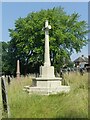
Cross of Sacrifice, Basford Cemetery
Standard Commonwealth War Graves Commission cross with simple inscriptions (no names). Looking unkempt, but this former cemetery is deliberately allowed to be a bit wild to encourage insect life.
Image: © Alan Murray-Rust
Taken: 20 Jul 2021
0.15 miles
9

Gravestones at Basford Cemetery
High Victorian stones, seen from Perry Road on a spring morning.
Image: © John Sutton
Taken: 28 Apr 2011
0.15 miles
10
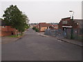
Nottingham - NG5 (Bagthorpe)
A view down the gentle slope at this end of Quorn Road - in the direction of Haydn Road - from the junction with Glendon Drive (just visible on the left). The premises of a couple of small factories (light industrial) characterise this end of the street, where the Quorn Road, Quorn Grove and Bagthorpe Close meet. The road widens as it heads into the distance towards Haydn Road.
Image: © David Hallam-Jones
Taken: 23 May 2012
0.16 miles