South from Perry Road bridge, 1963
Introduction
The photograph on this page of South from Perry Road bridge, 1963 by John Sutton as part of the Geograph project.
The Geograph project started in 2005 with the aim of publishing, organising and preserving representative images for every square kilometre of Great Britain, Ireland and the Isle of Man.

There are currently over 7.5m images from over 14,400 individuals and you can help contribute to the project by visiting https://www.geograph.org.uk
South from Perry Road bridge, 1963
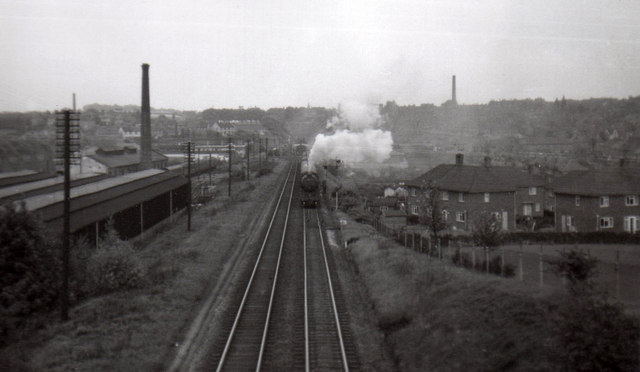
Image: © John Sutton Taken: Unknown
This was a good place for trainspotting on a schoolday evening, and seeing a Gresley V2 2-6-2 coming towards me on a northbound pigeon special was enough to make me press the shutter (far too soon). Much of what appears in this picture no longer exists, including the carriage sheds to the left (the site of Sheridan Way), New Basford station (behind the train) and the factory chimney on the right horizon. The council houses on the right are on Glamis Avenue. The cutting in the foreground has been filled in and built on. The historical interest of the picture (scanned and cropped from a tiny square print) may make up for its technical shortcomings. The Great Central Railway main line from London Marylebone to Sheffield via Leicester and Nottingham was the last trunk route to be completed (1899) and the first to close (1967). North of Nottingham and in the city much of its route has disappeared - embankments flattened, cuttings filled, viaducts demolished - and it is hard to follow. Compare with Image
Images are licensed for reuse under creativecommons.org/licenses/by-sa/2.0
Image Location
Latitude
52.981419
Longitude
-1.166334